La Excusa geodata
La Excusa (State of Mexico) is a populated place; located in Mexico in America/Mexico_City (GMT-6) time zone. With population of 844 people, there are 10365 cities with bigger population in this country. Compared to other cities in Mexico, 60.1% of cities are located further ↓South; 77.4% of cities are located further →East and 69% of cities have lower elevation than La Excusa. Note1


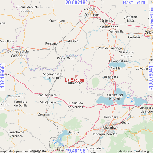
La Excusa GPS coordinates[2]
20° 8' 36.528" North, 101° 29' 36.708" West
| Map corner | latitude | longitude |
|---|---|---|
| Upper-left | 20.80219°, | -102.19666° |
| Center: | 20.14348°, | -101.49353° |
| Lower-right: | 19.48198°, | -100.79041° |
| Map W x H: | 146.8×146.8 km | = 91.2×91.2mi |
| max Lat: | 32.7° ⇑39.9% North |
| La Excusa: | 20.14348° |
| min Lat: | ⇓60.1% South 14.53588° |
| min Long | La Excusa | max Long |
| -117.105° | -101.49353° | -86.73105° |
| W 22.6%⇐ | ⇒77.4% E |
Elevation
Elevation of La Excusa is 1908 m = 6260 ft, and this is 654.3 m = 2147 ft above average elevation for this country.
| Max E: |
3497 m = 11473 ft | 31% |
| La Excusa | 1908 m 6260 ft | |
| Avg. | 1253.7 m = 4113 ft | |
Min E: |
-1 m = -3 ft | 69% |
See also: Mexico elevation on elevation.city.
Geographical zone
La Excusa is located in North Torrid zone (between Equator and Tropic of Cancer). Distance of this Northern Tropic circle is 366.2 km =227.5 mi to North.| Distance of | km | miles | from La Excusa |
|---|---|---|---|
| North Pole | 7767.3 | 4826.4 | to North |
| Arctic Circle | 5161.4 | 3207.1 | to North |
| Tropic Cancer | 366.2 | 227.5 | to North |
| Equator | 2239.7 | 1391.7 | to South |


Nearby cities:
15 places around La Excusa: (largest is in red/bold)
• Huatajo
4.4 km =2.7 mi,  28°
28°
• Isaac Arriaga (Santa Ana Mancera)
11.4 km =7.1 mi,  359°
359°
• Janambo
7.8 km =4.8 mi,  333°
333°
• Janamuato
10.8 km =6.7 mi,  243°
243°
• La Barranca
8.9 km =5.5 mi,  143°
143°
• Las Ranas
7.4 km =4.6 mi,  12°
12°
• Las Tortugas (Emiliano Zapata)
8.4 km =5.2 mi,  92°
92°
• Los Reyes
11.3 km =7 mi,  42°
42°
• Manuel Villalongín
11 km =6.8 mi,  341°
341°
• Puruándiro
6.5 km =4 mi,  200°
200°
• San José del Reparo
7.7 km =4.8 mi, 338°
• San Nicolás
4.6 km =2.9 mi, 326°
• San Pedro (San Pedro Carano)
2.6 km =1.6 mi,  232°
232°
• Santa Clara
7.4 km =4.6 mi,  57°
57°
• Tejocote de Calera
10.8 km =6.7 mi,  68°
68°
Sources, notices
• [Note1] Compared only with cities in Mexico existing in our database
• [Src1] Map data: © OpenStreetMap contributors (CC-BY-SA)
• [Src2] Other city data from geonames.org with taken over terms of usage.
• [Src3] Geographical zone / Annual Mean Temperature by Robert A. Rohde @ Wikipedia
