San Pedro (San Pedro Carano) geodata
San Pedro (San Pedro Carano) (Michoacán) is a populated place; located in Mexico in America/Mexico_City (GMT-6) time zone. With population of 503 people, there are 16722 cities with bigger population in this country. Compared to other cities in Mexico, 59.8% of cities are located further ↓South; 77.5% of cities are located further →East and 67.9% of cities have lower elevation than San Pedro (San Pedro Carano). Note1
Current local time in San Pedro (San Pedro Carano):
09:02 AM, MondayDifference from your time zone: hours


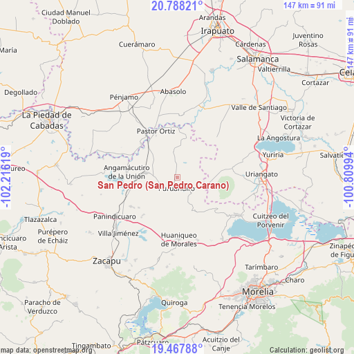
San Pedro (San Pedro Carano) GPS coordinates[2]
20° 7' 45.984" North, 101° 30' 47.016" West
| Map corner | latitude | longitude |
|---|---|---|
| Upper-left | 20.78821°, | -102.21619° |
| Center: | 20.12944°, | -101.51306° |
| Lower-right: | 19.46788°, | -100.80994° |
| Map W x H: | 146.8×146.8 km | = 91.2×91.2mi |
| max Lat: | 32.7° ⇑40.2% North |
| San Pedro (San Pedro Carano): | 20.12944° |
| min Lat: | ⇓59.8% South 14.53588° |
| min Long | San Pedro (San | max Long |
| -117.105° | -101.51306° | -86.73105° |
| W 22.5%⇐ | ⇒77.5% E |
Elevation
Elevation of San Pedro (San Pedro Carano) is 1887 m = 6191 ft, and this is 633.3 m = 2078 ft above average elevation for this country.
| Max E: |
3497 m = 11473 ft | 32.1% |
| San Pedro (San Pedro Carano) | 1887 m 6191 ft | |
| Avg. | 1253.7 m = 4113 ft | |
Min E: |
-1 m = -3 ft | 67.9% |
See also: Mexico elevation on elevation.city.
Geographical zone
San Pedro (San Pedro Carano) is located in North Torrid zone (between Equator and Tropic of Cancer). Distance of this Northern Tropic circle is 367.7 km =228.5 mi to North.| Distance of | km | miles | from San Pedro (San Pedro Carano) |
|---|---|---|---|
| North Pole | 7768.9 | 4827.4 | to North |
| Arctic Circle | 5163 | 3208.1 | to North |
| Tropic Cancer | 367.7 | 228.5 | to North |
| Equator | 2238.2 | 1390.8 | to South |


Nearby cities:
15 places around San Pedro (San Pedro Carano): (largest is in red/bold)
• Batuecas
10.5 km =6.5 mi,  159°
159°
• Galeana
12.1 km =7.5 mi,  210°
210°
• Huatajo
6.8 km =4.2 mi,  37°
37°
• Janambo
8.7 km =5.4 mi,  350°
350°
• Janamuato
8.2 km =5.1 mi,  246°
246°
• La Barranca
9.2 km =5.7 mi,  127°
127°
• La Excusa
2.6 km =1.6 mi,  52°
52°
• Las Ranas
9.5 km =5.9 mi,  22°
22°
• Las Tortugas (Emiliano Zapata)
10.5 km =6.5 mi,  83°
83°
• Manuel Villalongín
12.1 km =7.5 mi, 353°
• Puruándiro
4.5 km =2.8 mi,  183°
183°
• Sabino Buenavista
9.8 km =6.1 mi,  233°
233°
• San José del Reparo
8.7 km =5.4 mi,  355°
355°
• San Nicolás
5.4 km =3.4 mi, 354°
• Santa Clara
10 km =6.2 mi,  56°
56°
Sources, notices
• [Note1] Compared only with cities in Mexico existing in our database
• [Src1] Map data: © OpenStreetMap contributors (CC-BY-SA)
• [Src2] Other city data from geonames.org with taken over terms of usage.
• [Src3] Geographical zone / Annual Mean Temperature by Robert A. Rohde @ Wikipedia
