Barrio el Lindero geodata
Barrio el Lindero (State of Mexico) is a populated place; located in Mexico in America/Mexico_City (GMT-6) time zone. With population of 888 people, there are 9821 cities with bigger population in this country. Compared to other cities in Mexico, 51.1% of cities are located further ↓South; 60.3% of cities are located further →East and 98.4% of cities have lower elevation than Barrio el Lindero. Note1


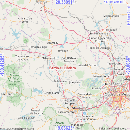
Barrio el Lindero GPS coordinates[2]
19° 43' 45.984" North, 99° 42' 34.992" West
| Map corner | latitude | longitude |
|---|---|---|
| Upper-left | 20.38991°, | -100.41285° |
| Center: | 19.72944°, | -99.70972° |
| Lower-right: | 19.06623°, | -99.0066° |
| Map W x H: | 147.2×147.2 km | = 91.5×91.5mi |
| max Lat: | 32.7° ⇑48.9% North |
| Barrio el Lindero: | 19.72944° |
| min Lat: | ⇓51.1% South 14.53588° |
| min Long | Barrio el Linde | max Long |
| -117.105° | -99.70972° | -86.73105° |
| W 39.7%⇐ | ⇒60.3% E |
Elevation
Elevation of Barrio el Lindero is 2781 m = 9124 ft, and this is 1527.3 m = 5011 ft above average elevation for this country.
| Max E: |
3497 m = 11473 ft | 1.6% |
| Barrio el Lindero | 2781 m 9124 ft | |
| Avg. | 1253.7 m = 4113 ft | |
Min E: |
-1 m = -3 ft | 98.4% |
See also: Mexico elevation on elevation.city.
Geographical zone
Barrio el Lindero is located in North Torrid zone (between Equator and Tropic of Cancer). Distance of this Northern Tropic circle is 412.2 km =256.1 mi to North.| Distance of | km | miles | from Barrio el Lindero |
|---|---|---|---|
| North Pole | 7813.4 | 4855 | to North |
| Arctic Circle | 5207.5 | 3235.8 | to North |
| Tropic Cancer | 412.2 | 256.1 | to North |
| Equator | 2193.7 | 1363.1 | to South |


Nearby cities:
15 places around Barrio el Lindero: (largest is in red/bold)
• Barrio Cuarto (La Loma)
5.5 km =3.4 mi,  38°
38°
• Barrio Primero (La Calavera)
6.9 km =4.3 mi,  22°
22°
• Barrio de Boyecha
3.6 km =2.2 mi,  132°
132°
• Barrio de la Luz
1.8 km =1.1 mi,  196°
196°
• Huemetla
3.2 km =2 mi,  239°
239°
• La Providencia
5.7 km =3.5 mi, 235°
• Laguna Seca
6.5 km =4 mi,  338°
338°
• Meje
4.1 km =2.5 mi,  163°
163°
• San Antonio Nixini
6.6 km =4.1 mi, 156°
• San Felipe Pueblo Nuevo
6.6 km =4.1 mi,  309°
309°
• San Francisco Chejé
6.8 km =4.2 mi,  216°
216°
• San José Boqui
3.7 km =2.3 mi,  212°
212°
• San José la Epifania
7.2 km =4.5 mi,  100°
100°
• Santiago Yeché
2.3 km =1.4 mi,  185°
185°
• Tiacaque
6.3 km =3.9 mi,  183°
183°
Sources, notices
• [Note1] Compared only with cities in Mexico existing in our database
• [Src1] Map data: © OpenStreetMap contributors (CC-BY-SA)
• [Src2] Other city data from geonames.org with taken over terms of usage.
• [Src3] Geographical zone / Annual Mean Temperature by Robert A. Rohde @ Wikipedia
