Guadalupe geodata
Guadalupe (Chiapas) is a populated place; located in Mexico in America/Mexico_City (GMT-6) time zone. With population of 1,687 people, there are 5148 cities with bigger population in this country. Compared to other cities in Mexico, 99.5% of cities are located further ↑North; 93.1% of cities are located further ←West and 76.4% of cities have higher elevation than Guadalupe. Note1


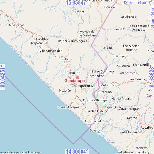
Guadalupe GPS coordinates[2]
14° 58' 49.188" North, 92° 20' 21.768" West
| Map corner | latitude | longitude |
|---|---|---|
| Upper-left | 15.65847°, | -93.04251° |
| Center: | 14.98033°, | -92.33938° |
| Lower-right: | 14.30004°, | -91.63626° |
| Map W x H: | 151×151 km | = 93.8×93.8mi |
| max Lat: | 32.7° ⇑99.5% North |
| Guadalupe: | 14.98033° |
| min Lat: | ⇓0.5% South 14.53588° |
| min Long | Guadalupe | max Long |
| -117.105° | -92.33938° | -86.73105° |
| W 93.1%⇐ | ⇒6.9% E |
Elevation
Elevation of Guadalupe is 172 m = 564 ft, and this is 1081.7 m = 3549 ft below average elevation for this country.
| Max E: |
3497 m = 11473 ft | 76.4% |
| Avg. | 1253.7 m = 4113 ft | |
| Guadalupe | 172 m = 564 ft | |
Min E: |
-1 m = -3 ft | 23.6% |
See also: Mexico elevation on elevation.city.
Geographical zone
Guadalupe is located in North Torrid zone (between Equator and Tropic of Cancer). Distance of this Northern Tropic circle is 940.3 km =584.3 mi to North.| Distance of | km | miles | from Guadalupe |
|---|---|---|---|
| North Pole | 8341.4 | 5183.1 | to North |
| Arctic Circle | 5735.5 | 3563.9 | to North |
| Tropic Cancer | 940.3 | 584.3 | to North |
| Equator | 1665.7 | 1035 | to South |


Nearby cities:
15 places around Guadalupe: (largest is in red/bold)
• Cuntalapa
8.1 km =5 mi,  309°
309°
• El Chaparrón
10.1 km =6.3 mi,  91°
91°
• El Edén
9.8 km =6.1 mi,  25°
25°
• Estación Huehuetán
8 km =5 mi,  295°
295°
• Guachipilín
9.9 km =6.2 mi,  272°
272°
• Huehuetán
6.4 km =4 mi, 313°
• Juan Sabines Gutiérrez (Poste Rojo)
6.9 km =4.3 mi,  188°
188°
• Manga de Clavo
8.3 km =5.2 mi,  109°
109°
• Nueva Granada
6 km =3.7 mi, 86°
• Nuevo Pumpuapa (Cereso)
6.7 km =4.2 mi,  204°
204°
• Pacayalito Dos
8.4 km =5.2 mi,  169°
169°
• Unión Miramar
4.2 km =2.6 mi, 199°
• Veinte de Noviembre
8 km =5 mi, 92°
• Viva México
7.9 km =4.9 mi, 169°
• Álvaro Obregón
7.7 km =4.8 mi,  212°
212°
Sources, notices
• [Note1] Compared only with cities in Mexico existing in our database
• [Src1] Map data: © OpenStreetMap contributors (CC-BY-SA)
• [Src2] Other city data from geonames.org with taken over terms of usage.
• [Src3] Geographical zone / Annual Mean Temperature by Robert A. Rohde @ Wikipedia
