Tampuchón geodata
Tampuchón (San Luis Potosí) is a populated place; located in Mexico in America/Mexico_City (GMT-6) time zone. With population of 874 people, there are 9993 cities with bigger population in this country. Compared to other cities in Mexico, 81.5% of cities are located further ↓South; 51% of cities are located further ←West and 68.6% of cities have higher elevation than Tampuchón. Note1


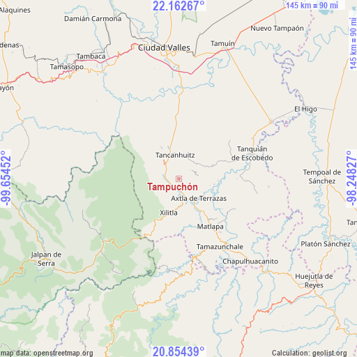
Tampuchón GPS coordinates[2]
21° 30' 36" North, 98° 57' 5.004" West
| Map corner | latitude | longitude |
|---|---|---|
| Upper-left | 22.16267°, | -99.65452° |
| Center: | 21.51°, | -98.95139° |
| Lower-right: | 20.85439°, | -98.24827° |
| Map W x H: | 145.5×145.5 km | = 90.4×90.4mi |
| max Lat: | 32.7° ⇑18.5% North |
| Tampuchón: | 21.51° |
| min Lat: | ⇓81.5% South 14.53588° |
| min Long | Tampuchón | max Long |
| -117.105° | -98.95139° | -86.73105° |
| W 51%⇐ | ⇒49% E |
Elevation
Elevation of Tampuchón is 493 m = 1617 ft, and this is 760.7 m = 2496 ft below average elevation for this country.
| Max E: |
3497 m = 11473 ft | 68.6% |
| Avg. | 1253.7 m = 4113 ft | |
| Tampuchón | 493 m = 1617 ft | |
Min E: |
-1 m = -3 ft | 31.4% |
See also: Mexico elevation on elevation.city.
Geographical zone
Tampuchón is located in North Torrid zone (between Equator and Tropic of Cancer). Distance of this Northern Tropic circle is 214.2 km =133.1 mi to North.| Distance of | km | miles | from Tampuchón |
|---|---|---|---|
| North Pole | 7615.4 | 4732 | to North |
| Arctic Circle | 5009.5 | 3112.8 | to North |
| Tropic Cancer | 214.2 | 133.1 | to North |
| Equator | 2391.7 | 1486.1 | to South |


Nearby cities:
15 places around Tampuchón: (largest is in red/bold)
• Ajuatitla Primera Sección
4.6 km =2.9 mi,  82°
82°
• Amaxac
5.7 km =3.5 mi,  103°
103°
• Chimalaco
5.6 km =3.5 mi,  167°
167°
• Coxcatlán
5.7 km =3.5 mi,  52°
52°
• Huehuetlán
4.4 km =2.7 mi,  337°
337°
• Huichihuayan
3.4 km =2.1 mi,  211°
211°
• Jilim Tantocoy Tres
4.1 km =2.5 mi,  282°
282°
• La Escalera
5.6 km =3.5 mi,  273°
273°
• La Pimienta
6.1 km =3.8 mi,  289°
289°
• Rancho Nuevo
6.3 km =3.9 mi,  164°
164°
• San Antonio Huitzquilico (Barrio Centro)
6.1 km =3.8 mi,  233°
233°
• Tanleab Uno
3.7 km =2.3 mi,  351°
351°
• Tantocoy Uno
4.7 km =2.9 mi,  299°
299°
• Tazaquil
2.4 km =1.5 mi,  150°
150°
• Tepotzuapa Primera Sección
4.3 km =2.7 mi,  140°
140°
Sources, notices
• [Note1] Compared only with cities in Mexico existing in our database
• [Src1] Map data: © OpenStreetMap contributors (CC-BY-SA)
• [Src2] Other city data from geonames.org with taken over terms of usage.
• [Src3] Geographical zone / Annual Mean Temperature by Robert A. Rohde @ Wikipedia
