Huehuetlán geodata
Huehuetlán (San Luis Potosí) is a seat of a second-order administrative division; located in Mexico in America/Mexico_City (GMT-6) time zone. With population of 562 people, there are 15183 cities with bigger population in this country. Compared to other cities in Mexico, 81.7% of cities are located further ↓South; 50.7% of cities are located further ←West and 71.2% of cities have higher elevation than Huehuetlán. Note1


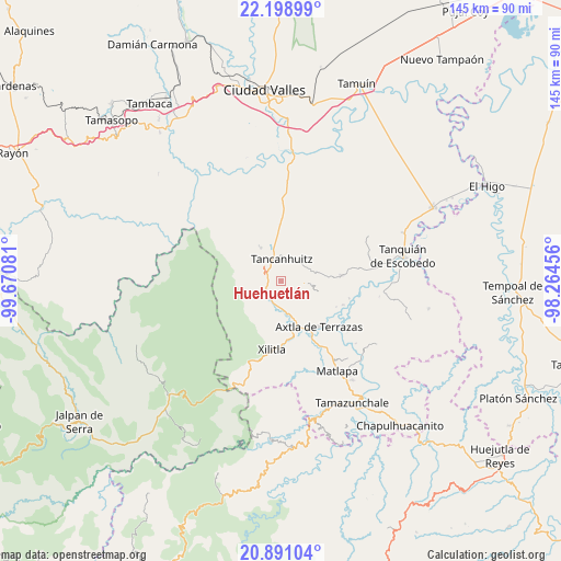
Huehuetlán GPS coordinates[2]
21° 32' 47.364" North, 98° 58' 3.648" West
| Map corner | latitude | longitude |
|---|---|---|
| Upper-left | 22.19899°, | -99.67081° |
| Center: | 21.54649°, | -98.96768° |
| Lower-right: | 20.89104°, | -98.26456° |
| Map W x H: | 145.4×145.4 km | = 90.3×90.3mi |
| max Lat: | 32.7° ⇑18.3% North |
| Huehuetlán: | 21.54649° |
| min Lat: | ⇓81.7% South 14.53588° |
| min Long | Huehuetlán | max Long |
| -117.105° | -98.96768° | -86.73105° |
| W 50.7%⇐ | ⇒49.3% E |
Elevation
Elevation of Huehuetlán is 362 m = 1188 ft, and this is 891.7 m = 2926 ft below average elevation for this country.
| Max E: |
3497 m = 11473 ft | 71.2% |
| Avg. | 1253.7 m = 4113 ft | |
| Huehuetlán | 362 m = 1188 ft | |
Min E: |
-1 m = -3 ft | 28.8% |
See also: Mexico elevation on elevation.city.
Geographical zone
Huehuetlán is located in North Torrid zone (between Equator and Tropic of Cancer). Distance of this Northern Tropic circle is 210.2 km =130.6 mi to North.| Distance of | km | miles | from Huehuetlán |
|---|---|---|---|
| North Pole | 7611.3 | 4729.4 | to North |
| Arctic Circle | 5005.4 | 3110.2 | to North |
| Tropic Cancer | 210.2 | 130.6 | to North |
| Equator | 2395.7 | 1488.6 | to South |


Nearby cities:
15 places around Huehuetlán: (largest is in red/bold)
• Ajuatitla Primera Sección
7.2 km =4.5 mi,  118°
118°
• Coxcatlán
6.3 km =3.9 mi,  95°
95°
• Cruz Blanca
3.7 km =2.3 mi,  260°
260°
• Huichihuayan
7 km =4.3 mi,  180°
180°
• Jilim Tantocoy Tres
4 km =2.5 mi,  216°
216°
• La Escalera
5.3 km =3.3 mi,  226°
226°
• La Pimienta
4.5 km =2.8 mi,  243°
243°
• Santa Bárbara
4.9 km =3 mi,  300°
300°
• Tampuchón
4.4 km =2.7 mi,  157°
157°
• Tancanhuitz
5.7 km =3.5 mi,  359°
359°
• Tandzumadz
2.5 km =1.6 mi,  328°
328°
• Tanleab Uno
1.2 km =0.7 mi,  108°
108°
• Tantocoy Uno
3 km =1.9 mi, 234°
• Tazaquil
6.8 km =4.2 mi, 155°
• Tzinejá Uno
2.2 km =1.4 mi,  2°
2°
Sources, notices
• [Note1] Compared only with cities in Mexico existing in our database
• [Src1] Map data: © OpenStreetMap contributors (CC-BY-SA)
• [Src2] Other city data from geonames.org with taken over terms of usage.
• [Src3] Geographical zone / Annual Mean Temperature by Robert A. Rohde @ Wikipedia
