Santa María I y II geodata
Santa María I y II (State of Mexico) is a populated place; located in Mexico in America/Mexico_City (GMT-6) time zone. With population of 844 people, there are 10365 cities with bigger population in this country. Compared to other cities in Mexico, 53.4% of cities are located further ↓South; 51.1% of cities are located further →East and 85.1% of cities have lower elevation than Santa María I y II. Note1


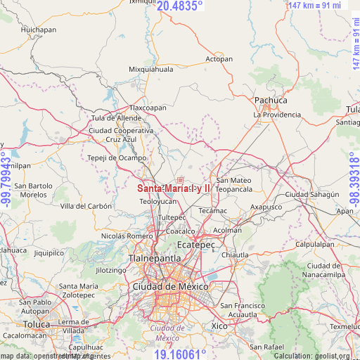
Santa María I y II GPS coordinates[2]
19° 49' 24.348" North, 99° 5' 46.68" West
| Map corner | latitude | longitude |
|---|---|---|
| Upper-left | 20.4835°, | -99.79943° |
| Center: | 19.82343°, | -99.0963° |
| Lower-right: | 19.16061°, | -98.39318° |
| Map W x H: | 147.1×147.1 km | = 91.4×91.4mi |
| max Lat: | 32.7° ⇑46.6% North |
| Santa María I y II: | 19.82343° |
| min Lat: | ⇓53.4% South 14.53588° |
| min Long | Santa María I | max Long |
| -117.105° | -99.0963° | -86.73105° |
| W 48.9%⇐ | ⇒51.1% E |
Elevation
Elevation of Santa María I y II is 2262 m = 7421 ft, and this is 1008.3 m = 3308 ft above average elevation for this country.
| Max E: |
3497 m = 11473 ft | 14.9% |
| Santa María I y II | 2262 m 7421 ft | |
| Avg. | 1253.7 m = 4113 ft | |
Min E: |
-1 m = -3 ft | 85.1% |
See also: Mexico elevation on elevation.city.
Geographical zone
Santa María I y II is located in North Torrid zone (between Equator and Tropic of Cancer). Distance of this Northern Tropic circle is 401.8 km =249.7 mi to North.| Distance of | km | miles | from Santa María I y II |
|---|---|---|---|
| North Pole | 7802.9 | 4848.5 | to North |
| Arctic Circle | 5197 | 3229.3 | to North |
| Tropic Cancer | 401.8 | 249.7 | to North |
| Equator | 2204.2 | 1369.6 | to South |


Nearby cities:
15 places around Santa María I y II: (largest is in red/bold)
• Arbolada los Sauces
5.5 km =3.4 mi,  98°
98°
• Barrio de España
4.5 km =2.8 mi,  19°
19°
• Colonia Wenceslao Labra
3 km =1.9 mi,  279°
279°
• Colonia los Hornos
4.9 km =3 mi,  109°
109°
• El Llano Santa María
4.5 km =2.8 mi,  166°
166°
• Fraccionamiento la Trinidad
1.6 km =1 mi,  65°
65°
• Loma Larga (Barrio de Loma Larga)
5.3 km =3.3 mi,  336°
336°
• Miguel Bocanegra
3 km =1.9 mi,  326°
326°
• San Juan Zitlaltepec
5.3 km =3.3 mi,  256°
256°
• San Miguel Bocanegra
2.8 km =1.7 mi,  324°
324°
• Santa María Cuevas
4.8 km =3 mi,  356°
356°
• Santa María de Guadalupe
3.3 km =2.1 mi,  265°
265°
• Unidad Familiar Confederación de Trabajadores Campesinos
5.5 km =3.4 mi,  161°
161°
• Villas de la Laguna
1.6 km =1 mi,  25°
25°
• Zumpango
3 km =1.9 mi,  186°
186°
Sources, notices
• [Note1] Compared only with cities in Mexico existing in our database
• [Src1] Map data: © OpenStreetMap contributors (CC-BY-SA)
• [Src2] Other city data from geonames.org with taken over terms of usage.
• [Src3] Geographical zone / Annual Mean Temperature by Robert A. Rohde @ Wikipedia
