Loma Larga (Barrio de Loma Larga) geodata
Loma Larga (Barrio de Loma Larga) (State of Mexico) is a populated place; located in Mexico in America/Mexico_City (GMT-6) time zone. With population of 2,196 people, there are 4000 cities with bigger population in this country. Compared to other cities in Mexico, 54.4% of cities are located further ↓South; 51.4% of cities are located further →East and 86.8% of cities have lower elevation than Loma Larga (Barrio de Loma Larga). Note1
Current local time in Loma Larga (Barrio de Loma Larga):
09:47 PM, TuesdayDifference from your time zone: hours


Loma Larga (Barrio de Loma Larga) GPS coordinates[2]
19° 52' 1.992" North, 99° 6' 57.996" West
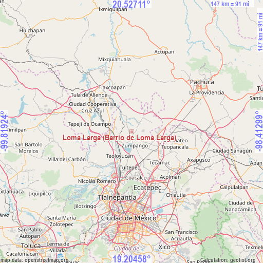
| Map corner | latitude | longitude |
|---|---|---|
| Upper-left | 20.52711°, | -99.81924° |
| Center: | 19.86722°, | -99.11611° |
| Lower-right: | 19.20458°, | -98.41299° |
| Map W x H: | 147.1×147.1 km | = 91.4×91.4mi |
| max Lat: | 32.7° ⇑45.6% North |
| Loma Larga (Barrio de Loma Larga): | 19.86722° |
| min Lat: | ⇓54.4% South 14.53588° |
| min Long | Loma Larga (Bar | max Long |
| -117.105° | -99.11611° | -86.73105° |
| W 48.6%⇐ | ⇒51.4% E |
Elevation
Elevation of Loma Larga (Barrio de Loma Larga) is 2304 m = 7559 ft, and this is 1050.3 m = 3446 ft above average elevation for this country.
| Max E: |
3497 m = 11473 ft | 13.2% |
| Loma Larga (Barrio de Loma Larga) | 2304 m 7559 ft | |
| Avg. | 1253.7 m = 4113 ft | |
Min E: |
-1 m = -3 ft | 86.8% |
See also: Mexico elevation on elevation.city.
Geographical zone
Loma Larga (Barrio de Loma Larga) is located in North Torrid zone (between Equator and Tropic of Cancer). Distance of this Northern Tropic circle is 396.9 km =246.6 mi to North.| Distance of | km | miles | from Loma Larga (Barrio de Loma Larga) |
|---|---|---|---|
| North Pole | 7798 | 4845.5 | to North |
| Arctic Circle | 5192.1 | 3226.2 | to North |
| Tropic Cancer | 396.9 | 246.6 | to North |
| Equator | 2209 | 1372.6 | to South |


Nearby cities:
15 places around Loma Larga (Barrio de Loma Larga): (largest is in red/bold)
• Barrio de España
3.7 km =2.3 mi,  100°
100°
• Barrio el Rincón
3.8 km =2.4 mi,  78°
78°
• Colonia Wenceslao Labra
4.5 km =2.8 mi,  191°
191°
• Fraccionamiento la Trinidad
5.5 km =3.4 mi,  140°
140°
• Hueypoxtla
6.7 km =4.2 mi,  40°
40°
• Jilotzingo
5.7 km =3.5 mi,  88°
88°
• Miguel Bocanegra
2.4 km =1.5 mi,  169°
169°
• San Juan Zitlaltepec
6.8 km =4.2 mi,  206°
206°
• San Miguel
1.9 km =1.2 mi,  274°
274°
• San Miguel Bocanegra
2.6 km =1.6 mi, 170°
• Santa María Cuevas
1.8 km =1.1 mi, 93°
• Santa María I y II
5.3 km =3.3 mi,  156°
156°
• Santa María de Guadalupe
5.3 km =3.3 mi, 193°
• Tequixquiac
5.6 km =3.5 mi,  327°
327°
• Villas de la Laguna
4.4 km =2.7 mi, 141°
Sources, notices
• [Note1] Compared only with cities in Mexico existing in our database
• [Src1] Map data: © OpenStreetMap contributors (CC-BY-SA)
• [Src2] Other city data from geonames.org with taken over terms of usage.
• [Src3] Geographical zone / Annual Mean Temperature by Robert A. Rohde @ Wikipedia
