La Soledad geodata
La Soledad (Michoacán) is a populated place; located in Mexico in America/Mexico_City (GMT-6) time zone. With population of 820 people, there are 10646 cities with bigger population in this country. Compared to other cities in Mexico, 55.8% of cities are located further ↑North; 69.4% of cities are located further →East and 52.7% of cities have higher elevation than La Soledad. Note1


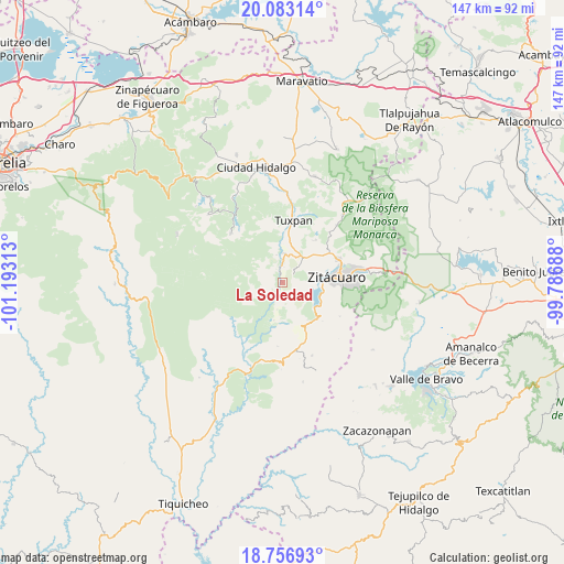
La Soledad GPS coordinates[2]
19° 25' 17.004" North, 100° 29' 24" West
| Map corner | latitude | longitude |
|---|---|---|
| Upper-left | 20.08314°, | -101.19313° |
| Center: | 19.42139°, | -100.49° |
| Lower-right: | 18.75693°, | -99.78688° |
| Map W x H: | 147.5×147.5 km | = 91.7×91.7mi |
| max Lat: | 32.7° ⇑55.8% North |
| La Soledad: | 19.42139° |
| min Lat: | ⇓44.2% South 14.53588° |
| min Long | La Soledad | max Long |
| -117.105° | -100.49° | -86.73105° |
| W 30.6%⇐ | ⇒69.4% E |
Elevation
Elevation of La Soledad is 1303 m = 4275 ft, and this is 49.3 m = 162 ft above average elevation for this country.
| Max E: |
3497 m = 11473 ft | 52.7% |
| La Soledad | 1303 m 4275 ft | |
| Avg. | 1253.7 m = 4113 ft | |
Min E: |
-1 m = -3 ft | 47.3% |
See also: Mexico elevation on elevation.city.
Geographical zone
La Soledad is located in North Torrid zone (between Equator and Tropic of Cancer). Distance of this Northern Tropic circle is 446.5 km =277.4 mi to North.| Distance of | km | miles | from La Soledad |
|---|---|---|---|
| North Pole | 7847.6 | 4876.3 | to North |
| Arctic Circle | 5241.7 | 3257 | to North |
| Tropic Cancer | 446.5 | 277.4 | to North |
| Equator | 2159.5 | 1341.9 | to South |


Nearby cities:
15 places around La Soledad: (largest is in red/bold)
• Agua Salada
6.3 km =3.9 mi,  51°
51°
• Camémbaro
9.6 km =6 mi,  86°
86°
• Cerrito del Muerto
7.7 km =4.8 mi,  17°
17°
• El Mango
7.4 km =4.6 mi,  34°
34°
• Huanguitío
2.7 km =1.7 mi,  174°
174°
• Ignacio López Rayón (Coyota Primera Manzana)
7.3 km =4.5 mi,  126°
126°
• Jungapeo de Juárez
4.2 km =2.6 mi,  353°
353°
• La Encarnación
10.3 km =6.4 mi,  95°
95°
• La Florida
7.3 km =4.5 mi,  191°
191°
• La Garita
6.2 km =3.9 mi,  2°
2°
• La Tinaja
6 km =3.7 mi, 2°
• Las Anonas
7.3 km =4.5 mi, 347°
• Lázaro Cárdenas
7.6 km =4.7 mi, 3°
• Manzana de la Mora
10.2 km =6.3 mi, 192°
• Ocurio
9.7 km =6 mi, 45°
Sources, notices
• [Note1] Compared only with cities in Mexico existing in our database
• [Src1] Map data: © OpenStreetMap contributors (CC-BY-SA)
• [Src2] Other city data from geonames.org with taken over terms of usage.
• [Src3] Geographical zone / Annual Mean Temperature by Robert A. Rohde @ Wikipedia
