Coyul geodata
Coyul (Oaxaca) is a populated place; located in Mexico in America/Mexico_City (GMT-6) time zone. With population of 807 people, there are 10824 cities with bigger population in this country. Compared to other cities in Mexico, 86.8% of cities are located further ↑North; 61.3% of cities are located further ←West and 55.4% of cities have higher elevation than Coyul. Note1


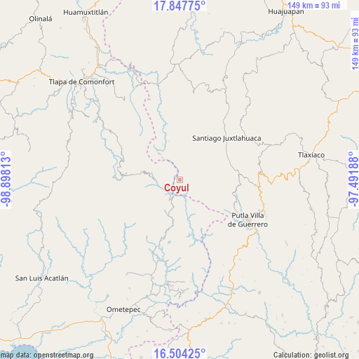
Coyul GPS coordinates[2]
17° 10' 37.992" North, 98° 11' 42" West
| Map corner | latitude | longitude |
|---|---|---|
| Upper-left | 17.84775°, | -98.89813° |
| Center: | 17.17722°, | -98.195° |
| Lower-right: | 16.50425°, | -97.49188° |
| Map W x H: | 149.4×149.4 km | = 92.8×92.8mi |
| max Lat: | 32.7° ⇑86.8% North |
| Coyul: | 17.17722° |
| min Lat: | ⇓13.2% South 14.53588° |
| min Long | Coyul | max Long |
| -117.105° | -98.195° | -86.73105° |
| W 61.3%⇐ | ⇒38.7% E |
Elevation
Elevation of Coyul is 1184 m = 3885 ft, and this is 69.7 m = 229 ft below average elevation for this country.
| Max E: |
3497 m = 11473 ft | 55.4% |
| Avg. | 1253.7 m = 4113 ft | |
| Coyul | 1184 m = 3885 ft | |
Min E: |
-1 m = -3 ft | 44.6% |
See also: Mexico elevation on elevation.city.
Geographical zone
Coyul is located in North Torrid zone (between Equator and Tropic of Cancer). Distance of this Northern Tropic circle is 696 km =432.5 mi to North.| Distance of | km | miles | from Coyul |
|---|---|---|---|
| North Pole | 8097.1 | 5031.3 | to North |
| Arctic Circle | 5491.2 | 3412.1 | to North |
| Tropic Cancer | 696 | 432.5 | to North |
| Equator | 1909.9 | 1186.8 | to South |


Nearby cities:
15 places around Coyul: (largest is in red/bold)
• El Coyul
14.6 km =9.1 mi,  204°
204°
• El Jicaral
5.7 km =3.5 mi,  182°
182°
• El Limón Guadalupe
6.1 km =3.8 mi,  229°
229°
• Jicayán de Tovar
7.1 km =4.4 mi,  218°
218°
• La Trinidad
11.6 km =7.2 mi,  174°
174°
• Rancho Pastor
9.9 km =6.2 mi,  327°
327°
• Rancho Viejo (Rancho Nuevo de la Democracia)
16.4 km =10.2 mi,  190°
190°
• San Juan Piñas
7.5 km =4.7 mi,  46°
46°
• San Marcos Xinicuesta
15.2 km =9.4 mi,  32°
32°
• San Miguel el Grande
8.7 km =5.4 mi, 330°
• Santa Cruz Yucucani
14.2 km =8.8 mi,  142°
142°
• Santiago Petlacala
16.8 km =10.4 mi,  323°
323°
• Santiago Tilapa
11.5 km =7.1 mi, 322°
• Santos Reyes Zochiquilazola
10 km =6.2 mi,  6°
6°
• Tierra Colorada
2.7 km =1.7 mi, 185°
Sources, notices
• [Note1] Compared only with cities in Mexico existing in our database
• [Src1] Map data: © OpenStreetMap contributors (CC-BY-SA)
• [Src2] Other city data from geonames.org with taken over terms of usage.
• [Src3] Geographical zone / Annual Mean Temperature by Robert A. Rohde @ Wikipedia
