El Jicaral geodata
El Jicaral (Guerrero) is a populated place; located in Mexico in America/Mexico_City (GMT-6) time zone. With population of 1,089 people, there are 7989 cities with bigger population in this country. Compared to other cities in Mexico, 87.4% of cities are located further ↑North; 61.3% of cities are located further ←West and 62.9% of cities have higher elevation than El Jicaral. Note1


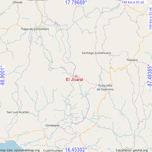
El Jicaral GPS coordinates[2]
17° 7' 34.212" North, 98° 11' 49.092" West
| Map corner | latitude | longitude |
|---|---|---|
| Upper-left | 17.79689°, | -98.9001° |
| Center: | 17.12617°, | -98.19697° |
| Lower-right: | 16.45302°, | -97.49385° |
| Map W x H: | 149.4×149.4 km | = 92.8×92.8mi |
| max Lat: | 32.7° ⇑87.4% North |
| El Jicaral: | 17.12617° |
| min Lat: | ⇓12.6% South 14.53588° |
| min Long | El Jicaral | max Long |
| -117.105° | -98.19697° | -86.73105° |
| W 61.3%⇐ | ⇒38.7% E |
Elevation
Elevation of El Jicaral is 829 m = 2720 ft, and this is 424.7 m = 1393 ft below average elevation for this country.
| Max E: |
3497 m = 11473 ft | 62.9% |
| Avg. | 1253.7 m = 4113 ft | |
| El Jicaral | 829 m = 2720 ft | |
Min E: |
-1 m = -3 ft | 37.1% |
See also: Mexico elevation on elevation.city.
Geographical zone
El Jicaral is located in North Torrid zone (between Equator and Tropic of Cancer). Distance of this Northern Tropic circle is 701.7 km =436 mi to North.| Distance of | km | miles | from El Jicaral |
|---|---|---|---|
| North Pole | 8102.8 | 5034.8 | to North |
| Arctic Circle | 5496.9 | 3415.6 | to North |
| Tropic Cancer | 701.7 | 436 | to North |
| Equator | 1904.3 | 1183.3 | to South |


Nearby cities:
15 places around El Jicaral: (largest is in red/bold)
• Arroyo Prieto
13.6 km =8.5 mi,  244°
244°
• Coyul
5.7 km =3.5 mi,  2°
2°
• El Coyul
9.6 km =6 mi,  218°
218°
• El Limón Guadalupe
4.8 km =3 mi,  291°
291°
• Jicayán de Tovar
4.2 km =2.6 mi,  271°
271°
• La Trinidad
6 km =3.7 mi,  167°
167°
• Rancho Pastor
14.9 km =9.3 mi,  339°
339°
• Rancho Viejo (Rancho Nuevo de la Democracia)
10.8 km =6.7 mi,  195°
195°
• Río Encajonado
15.7 km =9.8 mi,  233°
233°
• San Juan Piñas
12.2 km =7.6 mi,  27°
27°
• San Miguel el Grande
13.9 km =8.6 mi, 342°
• Santa Cruz Yucucani
10.5 km =6.5 mi,  121°
121°
• Santos Reyes Zochiquilazola
15.6 km =9.7 mi,  5°
5°
• Tierra Colorada
3 km =1.9 mi,  358°
358°
• Yoloxóchitl (Santiago Yoloxóchitl)
13.6 km =8.5 mi,  191°
191°
Sources, notices
• [Note1] Compared only with cities in Mexico existing in our database
• [Src1] Map data: © OpenStreetMap contributors (CC-BY-SA)
• [Src2] Other city data from geonames.org with taken over terms of usage.
• [Src3] Geographical zone / Annual Mean Temperature by Robert A. Rohde @ Wikipedia
