Las Delicias geodata
Las Delicias (Puebla) is a populated place; located in Mexico in America/Mexico_City (GMT-6) time zone. With population of 768 people, there are 11396 cities with bigger population in this country. Compared to other cities in Mexico, 53.7% of cities are located further ↓South; 70% of cities are located further ←West and 72.8% of cities have lower elevation than Las Delicias. Note1


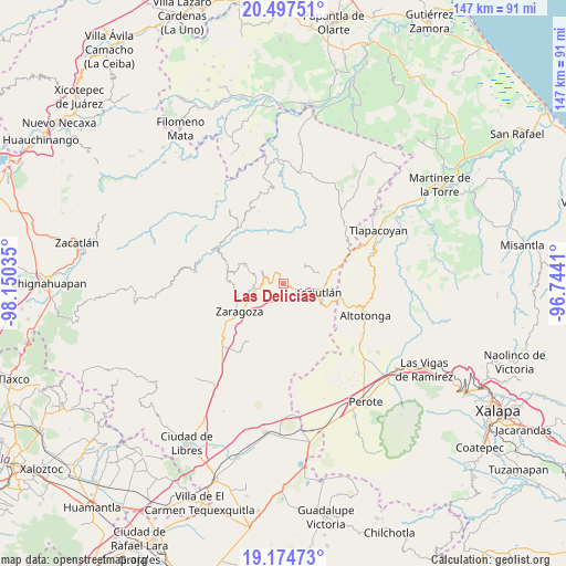
Las Delicias GPS coordinates[2]
19° 50' 15" North, 97° 26' 49.992" West
| Map corner | latitude | longitude |
|---|---|---|
| Upper-left | 20.49751°, | -98.15035° |
| Center: | 19.8375°, | -97.44722° |
| Lower-right: | 19.17473°, | -96.7441° |
| Map W x H: | 147.1×147.1 km | = 91.4×91.4mi |
| max Lat: | 32.7° ⇑46.3% North |
| Las Delicias: | 19.8375° |
| min Lat: | ⇓53.7% South 14.53588° |
| min Long | Las Delicias | max Long |
| -117.105° | -97.44722° | -86.73105° |
| W 70%⇐ | ⇒30% E |
Elevation
Elevation of Las Delicias is 1984 m = 6509 ft, and this is 730.3 m = 2396 ft above average elevation for this country.
| Max E: |
3497 m = 11473 ft | 27.2% |
| Las Delicias | 1984 m 6509 ft | |
| Avg. | 1253.7 m = 4113 ft | |
Min E: |
-1 m = -3 ft | 72.8% |
See also: Mexico elevation on elevation.city.
Geographical zone
Las Delicias is located in North Torrid zone (between Equator and Tropic of Cancer). Distance of this Northern Tropic circle is 400.2 km =248.7 mi to North.| Distance of | km | miles | from Las Delicias |
|---|---|---|---|
| North Pole | 7801.3 | 4847.5 | to North |
| Arctic Circle | 5195.5 | 3228.3 | to North |
| Tropic Cancer | 400.2 | 248.7 | to North |
| Equator | 2205.7 | 1370.6 | to South |


Nearby cities:
15 places around Las Delicias: (largest is in red/bold)
• Ahuatepec
4.1 km =2.5 mi,  23°
23°
• Atempan
1.2 km =0.7 mi,  280°
280°
• Atzalán
1.5 km =0.9 mi,  167°
167°
• Cala Norte
2.8 km =1.7 mi,  65°
65°
• Cala Sur
2.8 km =1.7 mi,  100°
100°
• Coacalco
3.2 km =2 mi,  42°
42°
• Ilita
3 km =1.9 mi,  295°
295°
• Las Canoas
2.5 km =1.6 mi,  176°
176°
• Pezmatlán
4.1 km =2.5 mi, 284°
• San Ambrosio
2 km =1.2 mi, 178°
• San Nicolás (Animazco)
0.5 km =0.3 mi,  0°
0°
• Tacopan
1.7 km =1.1 mi,  90°
90°
• Tanhuixco
2.8 km =1.7 mi,  228°
228°
• Teteles de Avila Castillo
2.4 km =1.5 mi,  335°
335°
• Tezhuatepec
3.3 km =2.1 mi,  209°
209°
Sources, notices
• [Note1] Compared only with cities in Mexico existing in our database
• [Src1] Map data: © OpenStreetMap contributors (CC-BY-SA)
• [Src2] Other city data from geonames.org with taken over terms of usage.
• [Src3] Geographical zone / Annual Mean Temperature by Robert A. Rohde @ Wikipedia
