Cala Sur geodata
Cala Sur (Puebla) is a populated place; located in Mexico in America/Mexico_City (GMT-6) time zone. With population of 2,511 people, there are 3522 cities with bigger population in this country. Compared to other cities in Mexico, 53.6% of cities are located further ↓South; 70.3% of cities are located further ←West and 78.3% of cities have lower elevation than Cala Sur. Note1


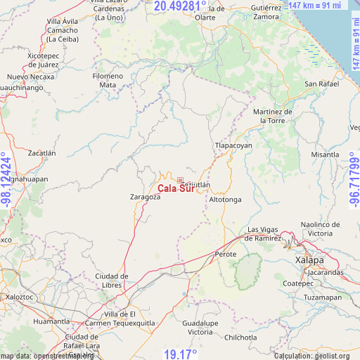
Cala Sur GPS coordinates[2]
19° 49' 58.008" North, 97° 25' 15.996" West
| Map corner | latitude | longitude |
|---|---|---|
| Upper-left | 20.49281°, | -98.12424° |
| Center: | 19.83278°, | -97.42111° |
| Lower-right: | 19.17°, | -96.71799° |
| Map W x H: | 147.1×147.1 km | = 91.4×91.4mi |
| max Lat: | 32.7° ⇑46.4% North |
| Cala Sur: | 19.83278° |
| min Lat: | ⇓53.6% South 14.53588° |
| min Long | Cala Sur | max Long |
| -117.105° | -97.42111° | -86.73105° |
| W 70.3%⇐ | ⇒29.7% E |
Elevation
Elevation of Cala Sur is 2096 m = 6877 ft, and this is 842.3 m = 2763 ft above average elevation for this country.
| Max E: |
3497 m = 11473 ft | 21.7% |
| Cala Sur | 2096 m 6877 ft | |
| Avg. | 1253.7 m = 4113 ft | |
Min E: |
-1 m = -3 ft | 78.3% |
See also: Mexico elevation on elevation.city.
Geographical zone
Cala Sur is located in North Torrid zone (between Equator and Tropic of Cancer). Distance of this Northern Tropic circle is 400.7 km =249 mi to North.| Distance of | km | miles | from Cala Sur |
|---|---|---|---|
| North Pole | 7801.9 | 4847.9 | to North |
| Arctic Circle | 5196 | 3228.6 | to North |
| Tropic Cancer | 400.7 | 249 | to North |
| Equator | 2205.2 | 1370.2 | to South |


Nearby cities:
15 places around Cala Sur: (largest is in red/bold)
• Analco
2.8 km =1.7 mi,  125°
125°
• Atempan
4 km =2.5 mi,  280°
280°
• Atzalán
2.6 km =1.6 mi,  249°
249°
• Cala Norte
1.7 km =1.1 mi,  353°
353°
• Chinautla
3.7 km =2.3 mi,  112°
112°
• Coacalco
2.9 km =1.8 mi, 348°
• Coahuixco
3.2 km =2 mi,  159°
159°
• Las Canoas
3.3 km =2.1 mi,  232°
232°
• Las Delicias
2.8 km =1.7 mi, 280°
• San Ambrosio
3 km =1.9 mi,  241°
241°
• San Nicolás (Animazco)
2.9 km =1.8 mi,  291°
291°
• Tacopan
1.2 km =0.7 mi,  296°
296°
• Talzintán
3.9 km =2.4 mi,  171°
171°
• Tepepan
4.1 km =2.5 mi,  89°
89°
• Tezohuatepec (Tezotepec)
3.4 km =2.1 mi,  138°
138°
Sources, notices
• [Note1] Compared only with cities in Mexico existing in our database
• [Src1] Map data: © OpenStreetMap contributors (CC-BY-SA)
• [Src2] Other city data from geonames.org with taken over terms of usage.
• [Src3] Geographical zone / Annual Mean Temperature by Robert A. Rohde @ Wikipedia
