Las Canoas geodata
Las Canoas (Puebla) is a populated place; located in Mexico in America/Mexico_City (GMT-6) time zone. With population of 584 people, there are 14684 cities with bigger population in this country. Compared to other cities in Mexico, 53.2% of cities are located further ↓South; 70.1% of cities are located further ←West and 77.8% of cities have lower elevation than Las Canoas. Note1


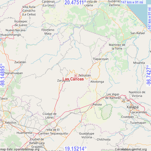
Las Canoas GPS coordinates[2]
19° 48' 54" North, 97° 26' 44.952" West
| Map corner | latitude | longitude |
|---|---|---|
| Upper-left | 20.47511°, | -98.14895° |
| Center: | 19.815°, | -97.44582° |
| Lower-right: | 19.15214°, | -96.7427° |
| Map W x H: | 147.1×147.1 km | = 91.4×91.4mi |
| max Lat: | 32.7° ⇑46.8% North |
| Las Canoas: | 19.815° |
| min Lat: | ⇓53.2% South 14.53588° |
| min Long | Las Canoas | max Long |
| -117.105° | -97.44582° | -86.73105° |
| W 70.1%⇐ | ⇒29.9% E |
Elevation
Elevation of Las Canoas is 2084 m = 6837 ft, and this is 830.3 m = 2724 ft above average elevation for this country.
| Max E: |
3497 m = 11473 ft | 22.2% |
| Las Canoas | 2084 m 6837 ft | |
| Avg. | 1253.7 m = 4113 ft | |
Min E: |
-1 m = -3 ft | 77.8% |
See also: Mexico elevation on elevation.city.
Geographical zone
Las Canoas is located in North Torrid zone (between Equator and Tropic of Cancer). Distance of this Northern Tropic circle is 402.7 km =250.2 mi to North.| Distance of | km | miles | from Las Canoas |
|---|---|---|---|
| North Pole | 7803.8 | 4849.1 | to North |
| Arctic Circle | 5198 | 3229.9 | to North |
| Tropic Cancer | 402.7 | 250.2 | to North |
| Equator | 2203.2 | 1369 | to South |


Nearby cities:
15 places around Las Canoas: (largest is in red/bold)
• Ajocotzingo
3.7 km =2.3 mi,  271°
271°
• Apatauyan
1.8 km =1.1 mi,  175°
175°
• Atempan
3 km =1.9 mi,  333°
333°
• Atzalán
1.1 km =0.7 mi,  9°
9°
• Cala Norte
4.4 km =2.7 mi,  33°
33°
• Cala Sur
3.3 km =2.1 mi,  52°
52°
• Coahuixco
3.9 km =2.4 mi,  105°
105°
• Las Delicias
2.5 km =1.6 mi,  356°
356°
• Pablogco
4.4 km =2.7 mi,  249°
249°
• San Ambrosio
0.5 km =0.3 mi,  350°
350°
• San Nicolás (Animazco)
3 km =1.9 mi, 357°
• Tacopan
2.9 km =1.8 mi, 31°
• Talzintán
3.6 km =2.2 mi,  120°
120°
• Tanhuixco
2.3 km =1.4 mi,  285°
285°
• Tezhuatepec
1.8 km =1.1 mi,  258°
258°
Sources, notices
• [Note1] Compared only with cities in Mexico existing in our database
• [Src1] Map data: © OpenStreetMap contributors (CC-BY-SA)
• [Src2] Other city data from geonames.org with taken over terms of usage.
• [Src3] Geographical zone / Annual Mean Temperature by Robert A. Rohde @ Wikipedia
