El Moral geodata
El Moral (Veracruz) is a populated place; located in Mexico in America/Mexico_City (GMT-6) time zone. With population of 574 people, there are 14926 cities with bigger population in this country. Compared to other cities in Mexico, 71.8% of cities are located further ↑North; 81.8% of cities are located further ←West and 90.8% of cities have higher elevation than El Moral. Note1


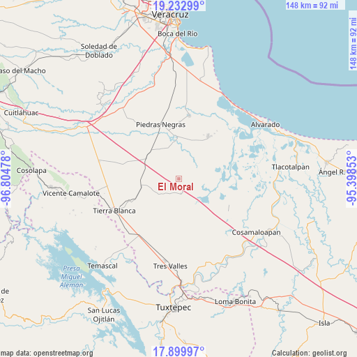
El Moral GPS coordinates[2]
18° 34' 4.008" North, 96° 6' 5.94" West
| Map corner | latitude | longitude |
|---|---|---|
| Upper-left | 19.23299°, | -96.80478° |
| Center: | 18.56778°, | -96.10165° |
| Lower-right: | 17.89997°, | -95.39853° |
| Map W x H: | 148.2×148.2 km | = 92.1×92.1mi |
| max Lat: | 32.7° ⇑71.8% North |
| El Moral: | 18.56778° |
| min Lat: | ⇓28.2% South 14.53588° |
| min Long | El Moral | max Long |
| -117.105° | -96.10165° | -86.73105° |
| W 81.8%⇐ | ⇒18.2% E |
Elevation
Elevation of El Moral is 22 m = 72 ft, and this is 1231.7 m = 4041 ft below average elevation for this country.
| Max E: |
3497 m = 11473 ft | 90.8% |
| Avg. | 1253.7 m = 4113 ft | |
| El Moral | 22 m = 72 ft | |
Min E: |
-1 m = -3 ft | 9.2% |
See also: Mexico elevation on elevation.city.
Geographical zone
El Moral is located in North Torrid zone (between Equator and Tropic of Cancer). Distance of this Northern Tropic circle is 541.4 km =336.4 mi to North.| Distance of | km | miles | from El Moral |
|---|---|---|---|
| North Pole | 7942.5 | 4935.2 | to North |
| Arctic Circle | 5336.6 | 3316 | to North |
| Tropic Cancer | 541.4 | 336.4 | to North |
| Equator | 2064.5 | 1282.8 | to South |


Nearby cities:
15 places around El Moral: (largest is in red/bold)
• Barahúnda
6.5 km =4 mi,  171°
171°
• El Cocuite
16.8 km =10.4 mi,  6°
6°
• El Contento
12.3 km =7.6 mi,  304°
304°
• El Jícaro
15.9 km =9.9 mi,  260°
260°
• El Salitral
15.2 km =9.4 mi,  49°
49°
• El Salto
11.5 km =7.1 mi,  35°
35°
• El Sauce (Cerro Grande)
16.5 km =10.3 mi, 12°
• Ideal de Arriba
14.8 km =9.2 mi,  180°
180°
• Joachín
15.9 km =9.9 mi, 299°
• La Isla
6.2 km =3.9 mi,  305°
305°
• Palma Cuata
16.4 km =10.2 mi,  32°
32°
• Paso Carretas
13.5 km =8.4 mi,  343°
343°
• Poblado Cinco (Nuevo Villa Ojitlán)
15.5 km =9.6 mi, 165°
• San Nicolás (La Burrera)
15.2 km =9.4 mi,  196°
196°
• Zacate Colorado Primero (El Moral)
16 km =9.9 mi, 45°
Sources, notices
• [Note1] Compared only with cities in Mexico existing in our database
• [Src1] Map data: © OpenStreetMap contributors (CC-BY-SA)
• [Src2] Other city data from geonames.org with taken over terms of usage.
• [Src3] Geographical zone / Annual Mean Temperature by Robert A. Rohde @ Wikipedia
