El Salitre geodata
El Salitre (State of Mexico) is a populated place; located in Mexico in America/Mexico_City (GMT-6) time zone. With population of 749 people, there are 11695 cities with bigger population in this country. Compared to other cities in Mexico, 68.4% of cities are located further ↑North; 59.8% of cities are located further →East and 61.4% of cities have lower elevation than El Salitre. Note1


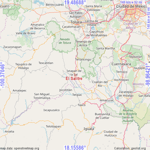
El Salitre GPS coordinates[2]
18° 49' 21.684" North, 99° 40' 2.388" West
| Map corner | latitude | longitude |
|---|---|---|
| Upper-left | 19.48688°, | -100.37046° |
| Center: | 18.82269°, | -99.66733° |
| Lower-right: | 18.15586°, | -98.96421° |
| Map W x H: | 148×148 km | = 92×92mi |
| max Lat: | 32.7° ⇑68.4% North |
| El Salitre: | 18.82269° |
| min Lat: | ⇓31.6% South 14.53588° |
| min Long | El Salitre | max Long |
| -117.105° | -99.66733° | -86.73105° |
| W 40.2%⇐ | ⇒59.8% E |
Elevation
Elevation of El Salitre is 1749 m = 5738 ft, and this is 495.3 m = 1625 ft above average elevation for this country.
| Max E: |
3497 m = 11473 ft | 38.6% |
| El Salitre | 1749 m 5738 ft | |
| Avg. | 1253.7 m = 4113 ft | |
Min E: |
-1 m = -3 ft | 61.4% |
See also: Mexico elevation on elevation.city.
Geographical zone
El Salitre is located in North Torrid zone (between Equator and Tropic of Cancer). Distance of this Northern Tropic circle is 513 km =318.8 mi to North.| Distance of | km | miles | from El Salitre |
|---|---|---|---|
| North Pole | 7914.2 | 4917.7 | to North |
| Arctic Circle | 5308.3 | 3298.4 | to North |
| Tropic Cancer | 513 | 318.8 | to North |
| Equator | 2092.9 | 1300.5 | to South |


Nearby cities:
15 places around El Salitre: (largest is in red/bold)
• Colonia 3 de Mayo
2.8 km =1.7 mi,  280°
280°
• El Progreso Hidalgo
6.2 km =3.9 mi,  64°
64°
• El Refugio
5 km =3.1 mi, 279°
• El Terrero
4.3 km =2.7 mi,  147°
147°
• Ixtapan de la Sal
2.5 km =1.6 mi,  337°
337°
• La Concepción (La Concha)
6.7 km =4.2 mi,  203°
203°
• La Finca
8.1 km =5 mi,  20°
20°
• La Puerta de Santiago
7.8 km =4.8 mi,  144°
144°
• Malinaltenango
6.5 km =4 mi,  224°
224°
• Mesón Nuevo
5.4 km =3.4 mi,  254°
254°
• San Alejo
6.7 km =4.2 mi,  285°
285°
• San Gaspar Tonatico
1.8 km =1.1 mi,  186°
186°
• San José del Arenal
6.6 km =4.1 mi,  319°
319°
• San Miguel Laderas
7.4 km =4.6 mi, 335°
• Tecomatepec
4.2 km =2.6 mi,  295°
295°
Sources, notices
• [Note1] Compared only with cities in Mexico existing in our database
• [Src1] Map data: © OpenStreetMap contributors (CC-BY-SA)
• [Src2] Other city data from geonames.org with taken over terms of usage.
• [Src3] Geographical zone / Annual Mean Temperature by Robert A. Rohde @ Wikipedia
