El Progreso Hidalgo geodata
El Progreso Hidalgo (State of Mexico) is a populated place; located in Mexico in America/Mexico_City (GMT-6) time zone. With population of 1,010 people, there are 8622 cities with bigger population in this country. Compared to other cities in Mexico, 68% of cities are located further ↑North; 58.8% of cities are located further →East and 59.4% of cities have lower elevation than El Progreso Hidalgo. Note1


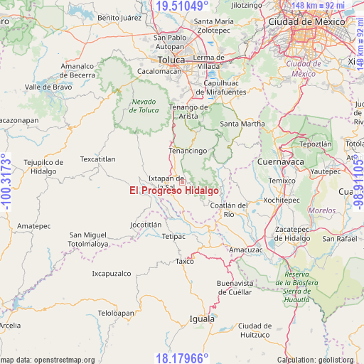
El Progreso Hidalgo GPS coordinates[2]
18° 50' 47.004" North, 99° 36' 51.012" West
| Map corner | latitude | longitude |
|---|---|---|
| Upper-left | 19.51049°, | -100.3173° |
| Center: | 18.84639°, | -99.61417° |
| Lower-right: | 18.17966°, | -98.91105° |
| Map W x H: | 148×148 km | = 92×92mi |
| max Lat: | 32.7° ⇑68% North |
| El Progreso Hidalgo: | 18.84639° |
| min Lat: | ⇓32% South 14.53588° |
| min Long | El Progreso Hid | max Long |
| -117.105° | -99.61417° | -86.73105° |
| W 41.2%⇐ | ⇒58.8% E |
Elevation
Elevation of El Progreso Hidalgo is 1716 m = 5630 ft, and this is 462.3 m = 1517 ft above average elevation for this country.
| Max E: |
3497 m = 11473 ft | 40.6% |
| El Progreso Hidalgo | 1716 m 5630 ft | |
| Avg. | 1253.7 m = 4113 ft | |
Min E: |
-1 m = -3 ft | 59.4% |
See also: Mexico elevation on elevation.city.
Geographical zone
El Progreso Hidalgo is located in North Torrid zone (between Equator and Tropic of Cancer). Distance of this Northern Tropic circle is 510.4 km =317.1 mi to North.| Distance of | km | miles | from El Progreso Hidalgo |
|---|---|---|---|
| North Pole | 7911.5 | 4916 | to North |
| Arctic Circle | 5305.7 | 3296.8 | to North |
| Tropic Cancer | 510.4 | 317.1 | to North |
| Equator | 2095.5 | 1302.1 | to South |


Nearby cities:
15 places around El Progreso Hidalgo: (largest is in red/bold)
• Ejido de la Finca
4.6 km =2.9 mi,  343°
343°
• El Salitre
6.2 km =3.9 mi,  244°
244°
• El Terrero
7 km =4.3 mi,  207°
207°
• Guadalupe Tlapizalco
3.7 km =2.3 mi,  5°
5°
• Ixtapan de la Sal
6.6 km =4.1 mi,  267°
267°
• La Ascensión
4.2 km =2.6 mi,  101°
101°
• La Finca
5.6 km =3.5 mi,  330°
330°
• Potrero Nuevo
6.1 km =3.8 mi,  345°
345°
• San Antonio Guadalupe
6.5 km =4 mi, 9°
• San Gaspar Tonatico
7.3 km =4.5 mi,  232°
232°
• San José Chalmita
7.1 km =4.4 mi,  78°
78°
• San Juan
3.6 km =2.2 mi,  91°
91°
• San Pablo Tejalpa
3.3 km =2.1 mi,  47°
47°
• Santa Catarina
5.2 km =3.2 mi,  37°
37°
• Zumpahuacán
3.7 km =2.3 mi,  106°
106°
Sources, notices
• [Note1] Compared only with cities in Mexico existing in our database
• [Src1] Map data: © OpenStreetMap contributors (CC-BY-SA)
• [Src2] Other city data from geonames.org with taken over terms of usage.
• [Src3] Geographical zone / Annual Mean Temperature by Robert A. Rohde @ Wikipedia
