Barrio de Guadalupe geodata
Barrio de Guadalupe (San Luis Potosí) is a populated place; located in Mexico in America/Mexico_City (GMT-6) time zone. With population of 717 people, there are 12151 cities with bigger population in this country. Compared to other cities in Mexico, 84% of cities are located further ↓South; 64.5% of cities are located further →East and 59.9% of cities have higher elevation than Barrio de Guadalupe. Note1


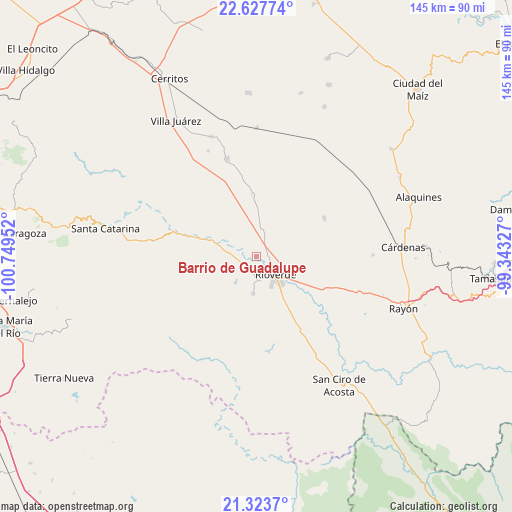
Barrio de Guadalupe GPS coordinates[2]
21° 58' 37.992" North, 100° 2' 47.004" West
| Map corner | latitude | longitude |
|---|---|---|
| Upper-left | 22.62774°, | -100.74952° |
| Center: | 21.97722°, | -100.04639° |
| Lower-right: | 21.3237°, | -99.34327° |
| Map W x H: | 145×145 km | = 90.1×90.1mi |
| max Lat: | 32.7° ⇑16% North |
| Barrio de Guadalupe: | 21.97722° |
| min Lat: | ⇓84% South 14.53588° |
| min Long | Barrio de Guada | max Long |
| -117.105° | -100.04639° | -86.73105° |
| W 35.5%⇐ | ⇒64.5% E |
Elevation
Elevation of Barrio de Guadalupe is 1010 m = 3314 ft, and this is 243.7 m = 800 ft below average elevation for this country.
| Max E: |
3497 m = 11473 ft | 59.9% |
| Avg. | 1253.7 m = 4113 ft | |
| Barrio de Guadalupe | 1010 m = 3314 ft | |
Min E: |
-1 m = -3 ft | 40.1% |
See also: Mexico elevation on elevation.city.
Geographical zone
Barrio de Guadalupe is located in North Torrid zone (between Equator and Tropic of Cancer). Distance of this Northern Tropic circle is 162.3 km =100.8 mi to North.| Distance of | km | miles | from Barrio de Guadalupe |
|---|---|---|---|
| North Pole | 7563.4 | 4699.7 | to North |
| Arctic Circle | 4957.5 | 3080.4 | to North |
| Tropic Cancer | 162.3 | 100.8 | to North |
| Equator | 2443.6 | 1518.4 | to South |


Nearby cities:
15 places around Barrio de Guadalupe: (largest is in red/bold)
• Cieneguilla
8.8 km =5.5 mi,  253°
253°
• Ciudad Fernández
5.4 km =3.4 mi,  138°
138°
• Colonia Veinte de Noviembre
0.4 km =0.2 mi,  301°
301°
• El Jabalí
10.4 km =6.5 mi,  183°
183°
• El Pescadito
12.4 km =7.7 mi,  203°
203°
• La Loma
10.6 km =6.6 mi,  211°
211°
• La Noria
8.5 km =5.3 mi, 299°
• La Reforma
5.5 km =3.4 mi, 295°
• La Tapona
13.7 km =8.5 mi,  278°
278°
• Labor Vieja
10.7 km =6.6 mi,  291°
291°
• Las Adjuntas
2.1 km =1.3 mi, 208°
• Ojo de Agua de Solano
3.5 km =2.2 mi, 284°
• Rioverde
7.4 km =4.6 mi,  133°
133°
• San Diego
8.8 km =5.5 mi,  220°
220°
• San Martín
8.2 km =5.1 mi, 223°
Sources, notices
• [Note1] Compared only with cities in Mexico existing in our database
• [Src1] Map data: © OpenStreetMap contributors (CC-BY-SA)
• [Src2] Other city data from geonames.org with taken over terms of usage.
• [Src3] Geographical zone / Annual Mean Temperature by Robert A. Rohde @ Wikipedia
