Pacheco geodata
Pacheco (Hidalgo) is a populated place; located in Mexico in America/Mexico_City (GMT-6) time zone. With population of 608 people, there are 14173 cities with bigger population in this country. Compared to other cities in Mexico, 62.8% of cities are located further ↓South; 50.5% of cities are located further →East and 72.2% of cities have lower elevation than Pacheco. Note1


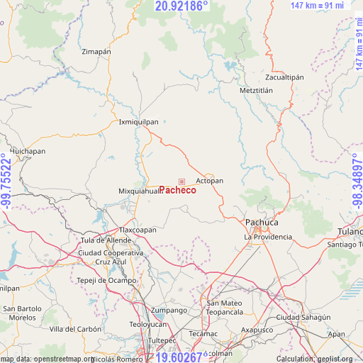
Pacheco GPS coordinates[2]
20° 15' 49.212" North, 99° 3' 7.524" West
| Map corner | latitude | longitude |
|---|---|---|
| Upper-left | 20.92186°, | -99.75522° |
| Center: | 20.26367°, | -99.05209° |
| Lower-right: | 19.60267°, | -98.34897° |
| Map W x H: | 146.7×146.7 km | = 91.2×91.2mi |
| max Lat: | 32.7° ⇑37.2% North |
| Pacheco: | 20.26367° |
| min Lat: | ⇓62.8% South 14.53588° |
| min Long | Pacheco | max Long |
| -117.105° | -99.05209° | -86.73105° |
| W 49.5%⇐ | ⇒50.5% E |
Elevation
Elevation of Pacheco is 1971 m = 6467 ft, and this is 717.3 m = 2353 ft above average elevation for this country.
| Max E: |
3497 m = 11473 ft | 27.8% |
| Pacheco | 1971 m 6467 ft | |
| Avg. | 1253.7 m = 4113 ft | |
Min E: |
-1 m = -3 ft | 72.2% |
See also: Mexico elevation on elevation.city.
Geographical zone
Pacheco is located in North Torrid zone (between Equator and Tropic of Cancer). Distance of this Northern Tropic circle is 352.8 km =219.2 mi to North.| Distance of | km | miles | from Pacheco |
|---|---|---|---|
| North Pole | 7754 | 4818.1 | to North |
| Arctic Circle | 5148.1 | 3198.9 | to North |
| Tropic Cancer | 352.8 | 219.2 | to North |
| Equator | 2253.1 | 1400 | to South |


Nearby cities:
15 places around Pacheco: (largest is in red/bold)
• Arambó
4.1 km =2.5 mi,  226°
226°
• Bocaja
4.5 km =2.8 mi,  81°
81°
• Bocamiño
3.1 km =1.9 mi,  219°
219°
• Demacú
5.1 km =3.2 mi,  26°
26°
• El Bondho
5.5 km =3.4 mi,  63°
63°
• El Olvera
2.9 km =1.8 mi, 75°
• El Rosario
3.3 km =2.1 mi,  121°
121°
• La Comunidad
3 km =1.9 mi,  235°
235°
• San Antonio Zaragoza
5.7 km =3.5 mi,  99°
99°
• San José Boxay
5.1 km =3.2 mi,  268°
268°
• San Juan Tepa
5.5 km =3.4 mi,  195°
195°
• San Miguel Acambay
1.4 km =0.9 mi,  347°
347°
• San Salvador
4.6 km =2.9 mi, 57°
• Tepatepec
4.4 km =2.7 mi, 243°
• Vixtha de Madero
1.7 km =1.1 mi,  49°
49°
Sources, notices
• [Note1] Compared only with cities in Mexico existing in our database
• [Src1] Map data: © OpenStreetMap contributors (CC-BY-SA)
• [Src2] Other city data from geonames.org with taken over terms of usage.
• [Src3] Geographical zone / Annual Mean Temperature by Robert A. Rohde @ Wikipedia
