Papalotla geodata
Papalotla (Puebla) is a populated place; located in Mexico in America/Mexico_City (GMT-6) time zone. With population of 713 people, there are 12219 cities with bigger population in this country. Compared to other cities in Mexico, 60.9% of cities are located further ↑North; 73.1% of cities are located further ←West and 90.8% of cities have lower elevation than Papalotla. Note1


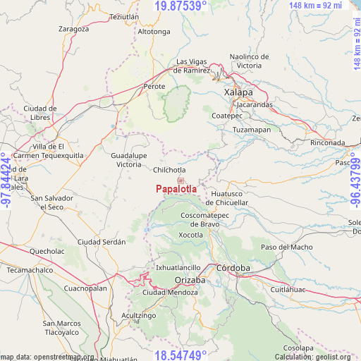
Papalotla GPS coordinates[2]
19° 12' 46.008" North, 97° 8' 27.996" West
| Map corner | latitude | longitude |
|---|---|---|
| Upper-left | 19.87539°, | -97.84424° |
| Center: | 19.21278°, | -97.14111° |
| Lower-right: | 18.54749°, | -96.43799° |
| Map W x H: | 147.6×147.7 km | = 91.7×91.8mi |
| max Lat: | 32.7° ⇑60.9% North |
| Papalotla: | 19.21278° |
| min Lat: | ⇓39.1% South 14.53588° |
| min Long | Papalotla | max Long |
| -117.105° | -97.14111° | -86.73105° |
| W 73.1%⇐ | ⇒26.9% E |
Elevation
Elevation of Papalotla is 2432 m = 7979 ft, and this is 1178.3 m = 3866 ft above average elevation for this country.
| Max E: |
3497 m = 11473 ft | 9.2% |
| Papalotla | 2432 m 7979 ft | |
| Avg. | 1253.7 m = 4113 ft | |
Min E: |
-1 m = -3 ft | 90.8% |
See also: Mexico elevation on elevation.city.
Geographical zone
Papalotla is located in North Torrid zone (between Equator and Tropic of Cancer). Distance of this Northern Tropic circle is 469.7 km =291.9 mi to North.| Distance of | km | miles | from Papalotla |
|---|---|---|---|
| North Pole | 7870.8 | 4890.7 | to North |
| Arctic Circle | 5264.9 | 3271.5 | to North |
| Tropic Cancer | 469.7 | 291.9 | to North |
| Equator | 2136.3 | 1327.4 | to South |


Nearby cities:
15 places around Papalotla: (largest is in red/bold)
• Acalocotla
5 km =3.1 mi,  141°
141°
• Atlaxco
6.1 km =3.8 mi,  117°
117°
• Colonia la Concepción
6.7 km =4.2 mi,  53°
53°
• El Rosario
7 km =4.3 mi,  79°
79°
• El Triunfo
3.5 km =2.2 mi,  295°
295°
• Jesús María Acatla
2.6 km =1.6 mi,  161°
161°
• Ojo de Agua
2.9 km =1.8 mi,  104°
104°
• Rafael J. García
6.4 km =4 mi,  316°
316°
• Rincón de los Reyes
2.9 km =1.8 mi,  225°
225°
• San José Acatla
3.3 km =2.1 mi, 137°
• Tlanepantla
0.9 km =0.6 mi, 54°
• Tozihuic
6.3 km =3.9 mi, 47°
• Xacaxomulco
2.8 km =1.7 mi,  193°
193°
• Xochimilco
3.9 km =2.4 mi, 99°
• Xopanapa
3.5 km =2.2 mi,  108°
108°
Sources, notices
• [Note1] Compared only with cities in Mexico existing in our database
• [Src1] Map data: © OpenStreetMap contributors (CC-BY-SA)
• [Src2] Other city data from geonames.org with taken over terms of usage.
• [Src3] Geographical zone / Annual Mean Temperature by Robert A. Rohde @ Wikipedia
