Atlaxco geodata
Atlaxco (Puebla) is a populated place; located in Mexico in America/Mexico_City (GMT-6) time zone. With population of 829 people, there are 10549 cities with bigger population in this country. Compared to other cities in Mexico, 61.5% of cities are located further ↑North; 73.7% of cities are located further ←West and 65% of cities have lower elevation than Atlaxco. Note1


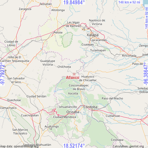
Atlaxco GPS coordinates[2]
19° 11' 13.668" North, 97° 5' 22.524" West
| Map corner | latitude | longitude |
|---|---|---|
| Upper-left | 19.84984°, | -97.79272° |
| Center: | 19.18713°, | -97.08959° |
| Lower-right: | 18.52174°, | -96.38647° |
| Map W x H: | 147.7×147.7 km | = 91.8×91.8mi |
| max Lat: | 32.7° ⇑61.5% North |
| Atlaxco: | 19.18713° |
| min Lat: | ⇓38.5% South 14.53588° |
| min Long | Atlaxco | max Long |
| -117.105° | -97.08959° | -86.73105° |
| W 73.7%⇐ | ⇒26.3% E |
Elevation
Elevation of Atlaxco is 1828 m = 5997 ft, and this is 574.3 m = 1884 ft above average elevation for this country.
| Max E: |
3497 m = 11473 ft | 35% |
| Atlaxco | 1828 m 5997 ft | |
| Avg. | 1253.7 m = 4113 ft | |
Min E: |
-1 m = -3 ft | 65% |
See also: Mexico elevation on elevation.city.
Geographical zone
Atlaxco is located in North Torrid zone (between Equator and Tropic of Cancer). Distance of this Northern Tropic circle is 472.5 km =293.6 mi to North.| Distance of | km | miles | from Atlaxco |
|---|---|---|---|
| North Pole | 7873.7 | 4892.5 | to North |
| Arctic Circle | 5267.8 | 3273.3 | to North |
| Tropic Cancer | 472.5 | 293.6 | to North |
| Equator | 2133.4 | 1325.6 | to South |


Nearby cities:
15 places around Atlaxco: (largest is in red/bold)
• Acalocotla
2.5 km =1.6 mi,  244°
244°
• Chichiquila
2.8 km =1.7 mi,  57°
57°
• Dos Ríos
1.5 km =0.9 mi,  103°
103°
• El Progreso
4.9 km =3 mi,  120°
120°
• El Rosario
4.3 km =2.7 mi,  19°
19°
• Elotepec
5.5 km =3.4 mi,  88°
88°
• Huaxcaleca
5.4 km =3.4 mi,  14°
14°
• Jesús María Acatla
4.6 km =2.9 mi,  274°
274°
• Ojo de Agua
3.4 km =2.1 mi,  308°
308°
• Rancho Nuevo
3.8 km =2.4 mi, 102°
• San José Acatla
3.2 km =2 mi,  277°
277°
• Tizapa
2.3 km =1.4 mi,  134°
134°
• Tlanepantla
5.8 km =3.6 mi, 305°
• Xochimilco
2.7 km =1.7 mi,  324°
324°
• Xopanapa
2.7 km =1.7 mi, 309°
Sources, notices
• [Note1] Compared only with cities in Mexico existing in our database
• [Src1] Map data: © OpenStreetMap contributors (CC-BY-SA)
• [Src2] Other city data from geonames.org with taken over terms of usage.
• [Src3] Geographical zone / Annual Mean Temperature by Robert A. Rohde @ Wikipedia
