La Reforma geodata
La Reforma (Veracruz) is a populated place; located in Mexico in America/Mexico_City (GMT-6) time zone. With population of 710 people, there are 12262 cities with bigger population in this country. Compared to other cities in Mexico, 74.2% of cities are located further ↓South; 67.8% of cities are located further ←West and 85.1% of cities have higher elevation than La Reforma. Note1


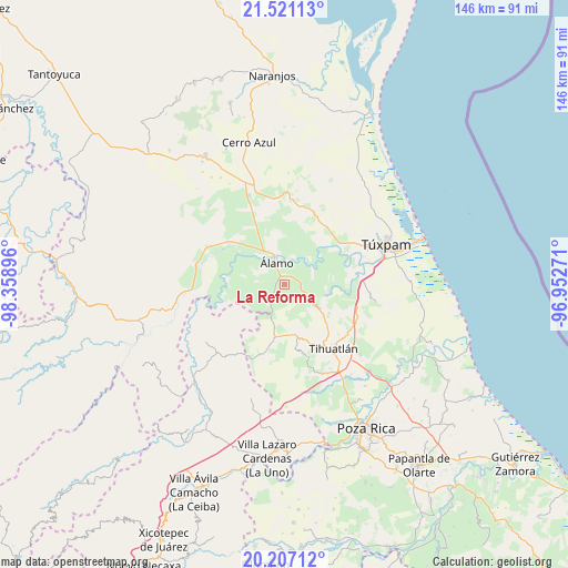
La Reforma GPS coordinates[2]
20° 51' 56.016" North, 97° 39' 20.988" West
| Map corner | latitude | longitude |
|---|---|---|
| Upper-left | 21.52113°, | -98.35896° |
| Center: | 20.86556°, | -97.65583° |
| Lower-right: | 20.20712°, | -96.95271° |
| Map W x H: | 146.1×146.1 km | = 90.8×90.8mi |
| max Lat: | 32.7° ⇑25.8% North |
| La Reforma: | 20.86556° |
| min Lat: | ⇓74.2% South 14.53588° |
| min Long | La Reforma | max Long |
| -117.105° | -97.65583° | -86.73105° |
| W 67.8%⇐ | ⇒32.2% E |
Elevation
Elevation of La Reforma is 43 m = 141 ft, and this is 1210.7 m = 3972 ft below average elevation for this country.
| Max E: |
3497 m = 11473 ft | 85.1% |
| Avg. | 1253.7 m = 4113 ft | |
| La Reforma | 43 m = 141 ft | |
Min E: |
-1 m = -3 ft | 14.9% |
See also: Mexico elevation on elevation.city.
Geographical zone
La Reforma is located in North Torrid zone (between Equator and Tropic of Cancer). Distance of this Northern Tropic circle is 285.9 km =177.6 mi to North.| Distance of | km | miles | from La Reforma |
|---|---|---|---|
| North Pole | 7687 | 4776.5 | to North |
| Arctic Circle | 5081.1 | 3157.2 | to North |
| Tropic Cancer | 285.9 | 177.6 | to North |
| Equator | 2320 | 1441.6 | to South |


Nearby cities:
15 places around La Reforma: (largest is in red/bold)
• Aquiles Serdán
4.3 km =2.7 mi,  228°
228°
• Buenos Aires (San Isidro)
6.3 km =3.9 mi,  116°
116°
• Cerro Dulce
5 km =3.1 mi, 117°
• Citlaltépetl
5 km =3.1 mi,  91°
91°
• El Bejucal
6.8 km =4.2 mi,  182°
182°
• Emiliano Zapata
6.7 km =4.2 mi,  268°
268°
• Estero del Ídolo
2.7 km =1.7 mi,  353°
353°
• Hidalgo Amajac
5.2 km =3.2 mi,  32°
32°
• Jardín Viejo
5.1 km =3.2 mi,  4°
4°
• La Concepción
2.5 km =1.6 mi,  264°
264°
• La Providencia
4.7 km =2.9 mi,  235°
235°
• La Tortuga
6.4 km =4 mi,  323°
323°
• La Unión
3.1 km =1.9 mi,  341°
341°
• Tincontlán
6.1 km =3.8 mi,  216°
216°
• Álamo
5.5 km =3.4 mi, 338°
Sources, notices
• [Note1] Compared only with cities in Mexico existing in our database
• [Src1] Map data: © OpenStreetMap contributors (CC-BY-SA)
• [Src2] Other city data from geonames.org with taken over terms of usage.
• [Src3] Geographical zone / Annual Mean Temperature by Robert A. Rohde @ Wikipedia
