La Providencia geodata
La Providencia (Veracruz) is a populated place; located in Mexico in America/Mexico_City (GMT-6) time zone. With population of 577 people, there are 14851 cities with bigger population in this country. Compared to other cities in Mexico, 73.9% of cities are located further ↓South; 67.3% of cities are located further ←West and 84.6% of cities have higher elevation than La Providencia. Note1


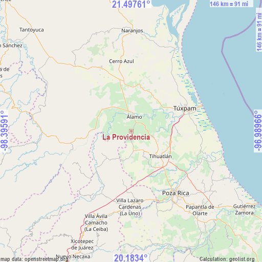
La Providencia GPS coordinates[2]
20° 50' 30.984" North, 97° 41' 34.008" West
| Map corner | latitude | longitude |
|---|---|---|
| Upper-left | 21.49761°, | -98.39591° |
| Center: | 20.84194°, | -97.69278° |
| Lower-right: | 20.1834°, | -96.98966° |
| Map W x H: | 146.1×146.1 km | = 90.8×90.8mi |
| max Lat: | 32.7° ⇑26.1% North |
| La Providencia: | 20.84194° |
| min Lat: | ⇓73.9% South 14.53588° |
| min Long | La Providencia | max Long |
| -117.105° | -97.69278° | -86.73105° |
| W 67.3%⇐ | ⇒32.7% E |
Elevation
Elevation of La Providencia is 47 m = 154 ft, and this is 1206.7 m = 3959 ft below average elevation for this country.
| Max E: |
3497 m = 11473 ft | 84.6% |
| Avg. | 1253.7 m = 4113 ft | |
| La Providencia | 47 m = 154 ft | |
Min E: |
-1 m = -3 ft | 15.4% |
See also: Mexico elevation on elevation.city.
Geographical zone
La Providencia is located in North Torrid zone (between Equator and Tropic of Cancer). Distance of this Northern Tropic circle is 288.5 km =179.3 mi to North.| Distance of | km | miles | from La Providencia |
|---|---|---|---|
| North Pole | 7689.7 | 4778.2 | to North |
| Arctic Circle | 5083.8 | 3158.9 | to North |
| Tropic Cancer | 288.5 | 179.3 | to North |
| Equator | 2317.4 | 1440 | to South |


Nearby cities:
15 places around La Providencia: (largest is in red/bold)
• Agua Nacida
8.2 km =5.1 mi,  349°
349°
• Aquiles Serdán
0.7 km =0.4 mi,  106°
106°
• El Bejucal
5.5 km =3.4 mi,  139°
139°
• Emiliano Zapata
3.7 km =2.3 mi,  311°
311°
• Estero del Ídolo
6.4 km =4 mi,  33°
33°
• La Concepción
2.7 km =1.7 mi, 29°
• La Reforma
4.7 km =2.9 mi,  55°
55°
• La Tortuga
7.8 km =4.8 mi,  0°
0°
• La Unión
6.3 km =3.9 mi, 27°
• Mequetla
5.3 km =3.3 mi,  175°
175°
• Palma Real de Adentro
6.2 km =3.9 mi,  217°
217°
• Rodríguez Clara
6.4 km =4 mi,  321°
321°
• Tincontlán
2.3 km =1.4 mi,  174°
174°
• Venustiano Carranza
4.1 km =2.5 mi,  243°
243°
• Álamo
7.9 km =4.9 mi,  13°
13°
Sources, notices
• [Note1] Compared only with cities in Mexico existing in our database
• [Src1] Map data: © OpenStreetMap contributors (CC-BY-SA)
• [Src2] Other city data from geonames.org with taken over terms of usage.
• [Src3] Geographical zone / Annual Mean Temperature by Robert A. Rohde @ Wikipedia
