El Gigante geodata
El Gigante (Michoacán) is a populated place; located in Mexico in America/Mexico_City (GMT-6) time zone. With population of 709 people, there are 12279 cities with bigger population in this country. Compared to other cities in Mexico, 56.4% of cities are located further ↓South; 69% of cities are located further →East and 72.9% of cities have lower elevation than El Gigante. Note1


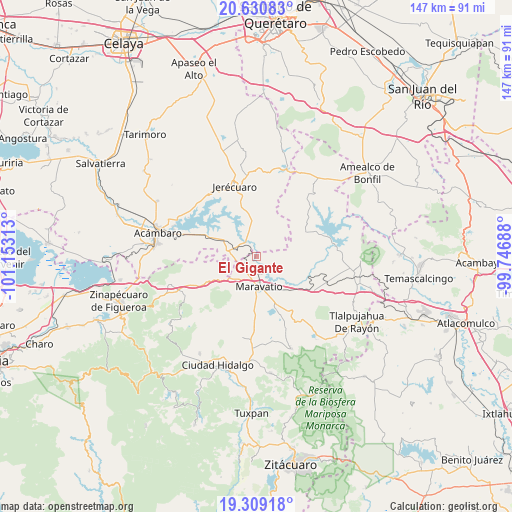
El Gigante GPS coordinates[2]
19° 58' 17.004" North, 100° 27' 0" West
| Map corner | latitude | longitude |
|---|---|---|
| Upper-left | 20.63083°, | -101.15313° |
| Center: | 19.97139°, | -100.45° |
| Lower-right: | 19.30918°, | -99.74688° |
| Map W x H: | 147×147 km | = 91.3×91.3mi |
| max Lat: | 32.7° ⇑43.6% North |
| El Gigante: | 19.97139° |
| min Lat: | ⇓56.4% South 14.53588° |
| min Long | El Gigante | max Long |
| -117.105° | -100.45° | -86.73105° |
| W 31%⇐ | ⇒69% E |
Elevation
Elevation of El Gigante is 1988 m = 6522 ft, and this is 734.3 m = 2409 ft above average elevation for this country.
| Max E: |
3497 m = 11473 ft | 27.1% |
| El Gigante | 1988 m 6522 ft | |
| Avg. | 1253.7 m = 4113 ft | |
Min E: |
-1 m = -3 ft | 72.9% |
See also: Mexico elevation on elevation.city.
Geographical zone
El Gigante is located in North Torrid zone (between Equator and Tropic of Cancer). Distance of this Northern Tropic circle is 385.3 km =239.4 mi to North.| Distance of | km | miles | from El Gigante |
|---|---|---|---|
| North Pole | 7786.5 | 4838.3 | to North |
| Arctic Circle | 5180.6 | 3219.1 | to North |
| Tropic Cancer | 385.3 | 239.4 | to North |
| Equator | 2220.6 | 1379.8 | to South |


Nearby cities:
15 places around El Gigante: (largest is in red/bold)
• Barrio de San Miguel
10.2 km =6.3 mi,  251°
251°
• Buenavista
8.2 km =5.1 mi,  305°
305°
• Casa Blanca
12 km =7.5 mi,  178°
178°
• Colonia Huandishi (Las Chinches)
11.9 km =7.4 mi,  124°
124°
• Colonia Yurécuaro
5.8 km =3.6 mi,  158°
158°
• El Tejero
12.4 km =7.7 mi,  150°
150°
• La Purísima
5.9 km =3.7 mi,  293°
293°
• Las Pilas de Puruagua
7.4 km =4.6 mi,  14°
14°
• Maravatío de Ocampo
8.9 km =5.5 mi, 176°
• Puroagua
12 km =7.5 mi,  358°
358°
• Sabino Seco
7.3 km =4.5 mi,  328°
328°
• Tarandacuao
7.9 km =4.9 mi, 294°
• Tungareo
11.2 km =7 mi,  128°
128°
• Tziritzícuaro
2 km =1.2 mi,  210°
210°
• Uripitio
9.4 km =5.8 mi,  257°
257°
Sources, notices
• [Note1] Compared only with cities in Mexico existing in our database
• [Src1] Map data: © OpenStreetMap contributors (CC-BY-SA)
• [Src2] Other city data from geonames.org with taken over terms of usage.
• [Src3] Geographical zone / Annual Mean Temperature by Robert A. Rohde @ Wikipedia
