La Purísima geodata
La Purísima (Guanajuato) is a populated place; located in Mexico in America/Mexico_City (GMT-6) time zone. With population of 586 people, there are 14641 cities with bigger population in this country. Compared to other cities in Mexico, 56.9% of cities are located further ↓South; 69.5% of cities are located further →East and 71.5% of cities have lower elevation than La Purísima. Note1


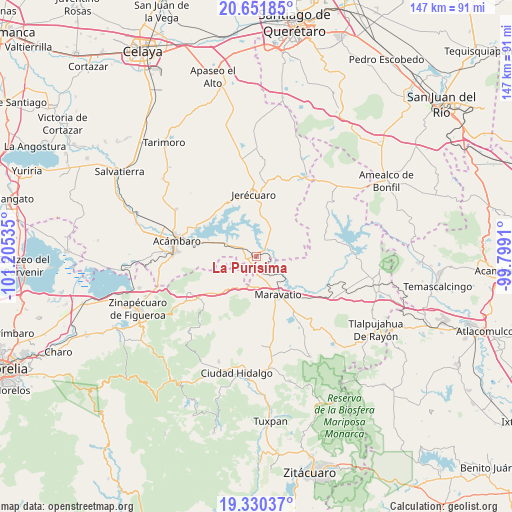
La Purísima GPS coordinates[2]
19° 59' 33" North, 100° 30' 7.992" West
| Map corner | latitude | longitude |
|---|---|---|
| Upper-left | 20.65185°, | -101.20535° |
| Center: | 19.9925°, | -100.50222° |
| Lower-right: | 19.33037°, | -99.7991° |
| Map W x H: | 146.9×146.9 km | = 91.3×91.3mi |
| max Lat: | 32.7° ⇑43.1% North |
| La Purísima: | 19.9925° |
| min Lat: | ⇓56.9% South 14.53588° |
| min Long | La Purísima | max Long |
| -117.105° | -100.50222° | -86.73105° |
| W 30.5%⇐ | ⇒69.5% E |
Elevation
Elevation of La Purísima is 1957 m = 6421 ft, and this is 703.3 m = 2307 ft above average elevation for this country.
| Max E: |
3497 m = 11473 ft | 28.5% |
| La Purísima | 1957 m 6421 ft | |
| Avg. | 1253.7 m = 4113 ft | |
Min E: |
-1 m = -3 ft | 71.5% |
See also: Mexico elevation on elevation.city.
Geographical zone
La Purísima is located in North Torrid zone (between Equator and Tropic of Cancer). Distance of this Northern Tropic circle is 383 km =238 mi to North.| Distance of | km | miles | from La Purísima |
|---|---|---|---|
| North Pole | 7784.1 | 4836.8 | to North |
| Arctic Circle | 5178.2 | 3217.6 | to North |
| Tropic Cancer | 383 | 238 | to North |
| Equator | 2223 | 1381.3 | to South |


Nearby cities:
15 places around La Purísima: (largest is in red/bold)
• Arroyo Colorado
12.7 km =7.9 mi,  278°
278°
• Arroyo de la Luna
10.1 km =6.3 mi,  289°
289°
• Barrio de San Miguel
7 km =4.3 mi,  217°
217°
• Buenavista
2.7 km =1.7 mi,  332°
332°
• Colonia Yurécuaro
10.8 km =6.7 mi,  135°
135°
• El Gigante
5.9 km =3.7 mi,  113°
113°
• Estanzuela de Razo
11.5 km =7.1 mi,  346°
346°
• Las Pilas de Puruagua
8.8 km =5.5 mi,  56°
56°
• Maravatío de Ocampo
12.8 km =8 mi,  151°
151°
• Puroagua
10.9 km =6.8 mi,  28°
28°
• Sabino Seco
4.2 km =2.6 mi,  23°
23°
• San Miguel Curinhuato
8.3 km =5.2 mi,  265°
265°
• Tarandacuao
1.9 km =1.2 mi,  298°
298°
• Tziritzícuaro
6 km =3.7 mi,  132°
132°
• Uripitio
5.7 km =3.5 mi, 220°
Sources, notices
• [Note1] Compared only with cities in Mexico existing in our database
• [Src1] Map data: © OpenStreetMap contributors (CC-BY-SA)
• [Src2] Other city data from geonames.org with taken over terms of usage.
• [Src3] Geographical zone / Annual Mean Temperature by Robert A. Rohde @ Wikipedia
