Emiliano Zapata geodata
Emiliano Zapata (Veracruz) is a populated place; located in Mexico in America/Mexico_City (GMT-6) time zone. With population of 701 people, there are 12418 cities with bigger population in this country. Compared to other cities in Mexico, 62.3% of cities are located further ↓South; 75.4% of cities are located further ←West and 86.7% of cities have higher elevation than Emiliano Zapata. Note1


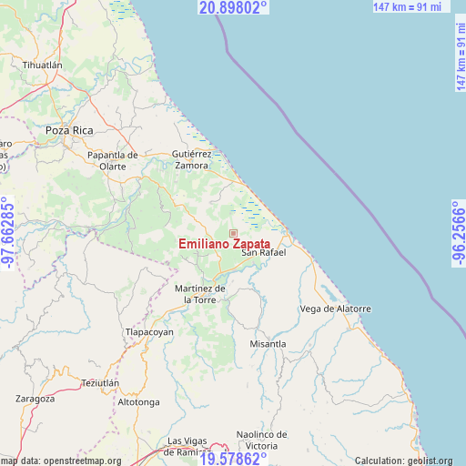
Emiliano Zapata GPS coordinates[2]
20° 14' 22.992" North, 96° 57' 34.992" West
| Map corner | latitude | longitude |
|---|---|---|
| Upper-left | 20.89802°, | -97.66285° |
| Center: | 20.23972°, | -96.95972° |
| Lower-right: | 19.57862°, | -96.2566° |
| Map W x H: | 146.7×146.7 km | = 91.2×91.2mi |
| max Lat: | 32.7° ⇑37.7% North |
| Emiliano Zapata: | 20.23972° |
| min Lat: | ⇓62.3% South 14.53588° |
| min Long | Emiliano Zapata | max Long |
| -117.105° | -96.95972° | -86.73105° |
| W 75.4%⇐ | ⇒24.6% E |
Elevation
Elevation of Emiliano Zapata is 35 m = 115 ft, and this is 1218.7 m = 3998 ft below average elevation for this country.
| Max E: |
3497 m = 11473 ft | 86.7% |
| Avg. | 1253.7 m = 4113 ft | |
| Emiliano Zapata | 35 m = 115 ft | |
Min E: |
-1 m = -3 ft | 13.3% |
See also: Mexico elevation on elevation.city.
Geographical zone
Emiliano Zapata is located in North Torrid zone (between Equator and Tropic of Cancer). Distance of this Northern Tropic circle is 355.5 km =220.9 mi to North.| Distance of | km | miles | from Emiliano Zapata |
|---|---|---|---|
| North Pole | 7756.6 | 4819.7 | to North |
| Arctic Circle | 5150.7 | 3200.5 | to North |
| Tropic Cancer | 355.5 | 220.9 | to North |
| Equator | 2250.4 | 1398.3 | to South |


Nearby cities:
15 places around Emiliano Zapata: (largest is in red/bold)
• Arroyo Blanco
10.8 km =6.7 mi,  255°
255°
• Cementeras del Pital
9.7 km =6 mi,  136°
136°
• Ejido Vega de San Marcos
4.9 km =3 mi,  153°
153°
• El Cabellal
3.5 km =2.2 mi,  288°
288°
• El Faisán
8.1 km =5 mi,  220°
220°
• El Pital
11.2 km =7 mi, 145°
• Felipe Carrillo Puerto
11.6 km =7.2 mi,  175°
175°
• Fuerte de Anaya
6.4 km =4 mi,  352°
352°
• Guadalupe Victoria
9.3 km =5.8 mi, 149°
• Insurgentes
9.3 km =5.8 mi,  160°
160°
• Manuel Ávila Camacho
6.4 km =4 mi,  240°
240°
• Puntilla Aldama
7.9 km =4.9 mi, 135°
• Salvador Díaz Mirón
11.4 km =7.1 mi,  231°
231°
• San Rafael
11.2 km =7 mi,  120°
120°
• Zanjas de Arena
7.1 km =4.4 mi, 237°
Sources, notices
• [Note1] Compared only with cities in Mexico existing in our database
• [Src1] Map data: © OpenStreetMap contributors (CC-BY-SA)
• [Src2] Other city data from geonames.org with taken over terms of usage.
• [Src3] Geographical zone / Annual Mean Temperature by Robert A. Rohde @ Wikipedia
