Santa Ana geodata
Santa Ana (Chiapas) is a populated place; located in Mexico in America/Mexico_City (GMT-6) time zone. With population of 582 people, there are 14734 cities with bigger population in this country. Compared to other cities in Mexico, 91.6% of cities are located further ↑North; 90.2% of cities are located further ←West and 91.9% of cities have lower elevation than Santa Ana. Note1


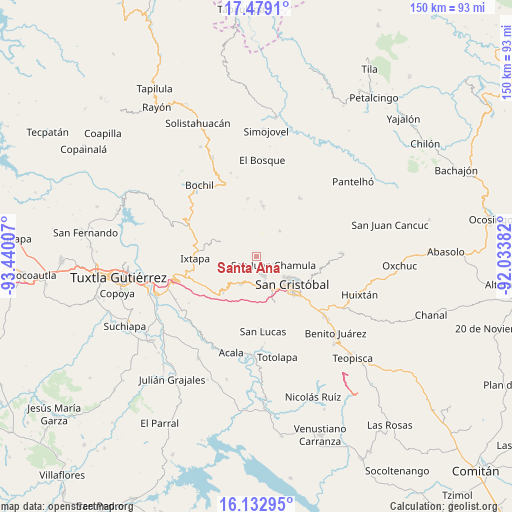
Santa Ana GPS coordinates[2]
16° 48' 25.992" North, 92° 44' 12.984" West
| Map corner | latitude | longitude |
|---|---|---|
| Upper-left | 17.4791°, | -93.44007° |
| Center: | 16.80722°, | -92.73694° |
| Lower-right: | 16.13295°, | -92.03382° |
| Map W x H: | 149.7×149.7 km | = 93×93mi |
| max Lat: | 32.7° ⇑91.6% North |
| Santa Ana: | 16.80722° |
| min Lat: | ⇓8.4% South 14.53588° |
| min Long | Santa Ana | max Long |
| -117.105° | -92.73694° | -86.73105° |
| W 90.2%⇐ | ⇒9.8% E |
Elevation
Elevation of Santa Ana is 2476 m = 8123 ft, and this is 1222.3 m = 4010 ft above average elevation for this country.
| Max E: |
3497 m = 11473 ft | 8.1% |
| Santa Ana | 2476 m 8123 ft | |
| Avg. | 1253.7 m = 4113 ft | |
Min E: |
-1 m = -3 ft | 91.9% |
See also: Mexico elevation on elevation.city.
Geographical zone
Santa Ana is located in North Torrid zone (between Equator and Tropic of Cancer). Distance of this Northern Tropic circle is 737.1 km =458 mi to North.| Distance of | km | miles | from Santa Ana |
|---|---|---|---|
| North Pole | 8138.3 | 5056.9 | to North |
| Arctic Circle | 5532.4 | 3437.7 | to North |
| Tropic Cancer | 737.1 | 458 | to North |
| Equator | 1868.8 | 1161.2 | to South |


Nearby cities:
15 places around Santa Ana: (largest is in red/bold)
• Arvenza Uno
3.5 km =2.2 mi,  149°
149°
• Bahosil
3.3 km =2.1 mi,  162°
162°
• Bautista Chico
2.8 km =1.7 mi,  107°
107°
• Bautista Grande
1.4 km =0.9 mi,  140°
140°
• Catishtic
3 km =1.9 mi,  181°
181°
• Cruz Quemada
4.9 km =3 mi,  67°
67°
• Cuchulumtic
4.8 km =3 mi,  133°
133°
• Jomalho
4.2 km =2.6 mi,  30°
30°
• Nichén
5.7 km =3.5 mi,  96°
96°
• Noctic
3.3 km =2.1 mi,  252°
252°
• Seteltón
1.3 km =0.8 mi,  61°
61°
• Tzajaltetic
3.9 km =2.4 mi,  80°
80°
• Ukumtic
1.9 km =1.2 mi, 159°
• Yaaltz'Unun
3.9 km =2.4 mi,  269°
269°
• Zinacantán
5.4 km =3.4 mi, 163°
Sources, notices
• [Note1] Compared only with cities in Mexico existing in our database
• [Src1] Map data: © OpenStreetMap contributors (CC-BY-SA)
• [Src2] Other city data from geonames.org with taken over terms of usage.
• [Src3] Geographical zone / Annual Mean Temperature by Robert A. Rohde @ Wikipedia
