La Santa Cruz geodata
La Santa Cruz (Guanajuato) is a populated place; located in Mexico in America/Mexico_City (GMT-6) time zone. With population of 663 people, there are 13102 cities with bigger population in this country. Compared to other cities in Mexico, 78.8% of cities are located further ↓South; 78.4% of cities are located further →East and 67.9% of cities have lower elevation than La Santa Cruz. Note1


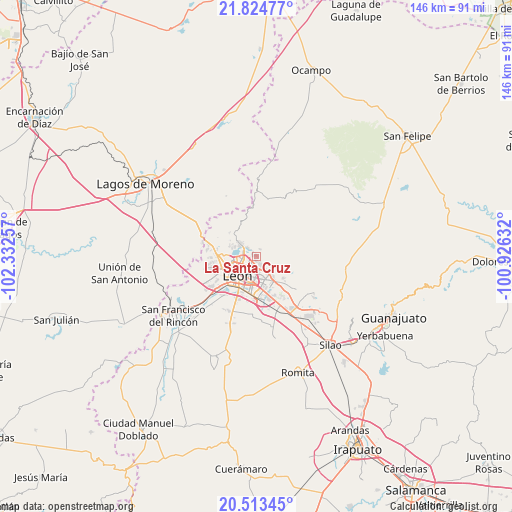
La Santa Cruz GPS coordinates[2]
21° 10' 14.016" North, 101° 37' 45.984" West
| Map corner | latitude | longitude |
|---|---|---|
| Upper-left | 21.82477°, | -102.33257° |
| Center: | 21.17056°, | -101.62944° |
| Lower-right: | 20.51345°, | -100.92632° |
| Map W x H: | 145.8×145.8 km | = 90.6×90.6mi |
| max Lat: | 32.7° ⇑21.2% North |
| La Santa Cruz: | 21.17056° |
| min Lat: | ⇓78.8% South 14.53588° |
| min Long | La Santa Cruz | max Long |
| -117.105° | -101.62944° | -86.73105° |
| W 21.6%⇐ | ⇒78.4% E |
Elevation
Elevation of La Santa Cruz is 1887 m = 6191 ft, and this is 633.3 m = 2078 ft above average elevation for this country.
| Max E: |
3497 m = 11473 ft | 32.1% |
| La Santa Cruz | 1887 m 6191 ft | |
| Avg. | 1253.7 m = 4113 ft | |
Min E: |
-1 m = -3 ft | 67.9% |
See also: Mexico elevation on elevation.city.
Geographical zone
La Santa Cruz is located in North Torrid zone (between Equator and Tropic of Cancer). Distance of this Northern Tropic circle is 252 km =156.6 mi to North.| Distance of | km | miles | from La Santa Cruz |
|---|---|---|---|
| North Pole | 7653.1 | 4755.4 | to North |
| Arctic Circle | 5047.2 | 3136.2 | to North |
| Tropic Cancer | 252 | 156.6 | to North |
| Equator | 2353.9 | 1462.6 | to South |


Nearby cities:
15 places around La Santa Cruz: (largest is in red/bold)
• Alfaro
3.4 km =2.1 mi,  134°
134°
• Cristo Rey
8.6 km =5.3 mi,  142°
142°
• El Penitente
1.4 km =0.9 mi,  324°
324°
• Fraccionamiento Paraíso Real
8.2 km =5.1 mi, 142°
• Hacienda Arriba
10.4 km =6.5 mi,  312°
312°
• Ibarrilla
2.5 km =1.6 mi, 316°
• La Patiña
8.2 km =5.1 mi,  291°
291°
• León de los Aldama
6.5 km =4 mi,  224°
224°
• Los Naranjos
0.4 km =0.2 mi, 135°
• Lucio Blanco (Los Gavilanes)
10.2 km =6.3 mi, 127°
• Medina
2.4 km =1.5 mi,  162°
162°
• Ojo de Agua de los Reyes
2.3 km =1.4 mi,  23°
23°
• Rivera del Carmen (Divina Infantita)
1.7 km =1.1 mi, 322°
• San José del Potrero
5.8 km =3.6 mi, 144°
• San Juan de Otates
9.6 km =6 mi, 129°
Sources, notices
• [Note1] Compared only with cities in Mexico existing in our database
• [Src1] Map data: © OpenStreetMap contributors (CC-BY-SA)
• [Src2] Other city data from geonames.org with taken over terms of usage.
• [Src3] Geographical zone / Annual Mean Temperature by Robert A. Rohde @ Wikipedia
