El Penitente geodata
El Penitente (Guanajuato) is a populated place; located in Mexico in America/Mexico_City (GMT-6) time zone. With population of 522 people, there are 16162 cities with bigger population in this country. Compared to other cities in Mexico, 78.9% of cities are located further ↓South; 78.5% of cities are located further →East and 67.3% of cities have lower elevation than El Penitente. Note1


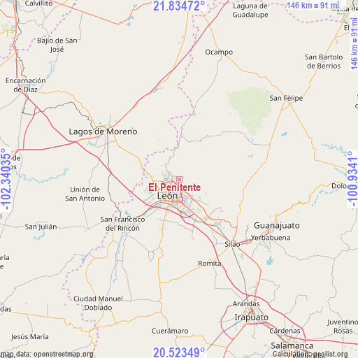
El Penitente GPS coordinates[2]
21° 10' 50.016" North, 101° 38' 13.992" West
| Map corner | latitude | longitude |
|---|---|---|
| Upper-left | 21.83472°, | -102.34035° |
| Center: | 21.18056°, | -101.63722° |
| Lower-right: | 20.52349°, | -100.9341° |
| Map W x H: | 145.8×145.8 km | = 90.6×90.6mi |
| max Lat: | 32.7° ⇑21.1% North |
| El Penitente: | 21.18056° |
| min Lat: | ⇓78.9% South 14.53588° |
| min Long | El Penitente | max Long |
| -117.105° | -101.63722° | -86.73105° |
| W 21.5%⇐ | ⇒78.5% E |
Elevation
Elevation of El Penitente is 1875 m = 6152 ft, and this is 621.3 m = 2038 ft above average elevation for this country.
| Max E: |
3497 m = 11473 ft | 32.7% |
| El Penitente | 1875 m 6152 ft | |
| Avg. | 1253.7 m = 4113 ft | |
Min E: |
-1 m = -3 ft | 67.3% |
See also: Mexico elevation on elevation.city.
Geographical zone
El Penitente is located in North Torrid zone (between Equator and Tropic of Cancer). Distance of this Northern Tropic circle is 250.9 km =155.9 mi to North.| Distance of | km | miles | from El Penitente |
|---|---|---|---|
| North Pole | 7652 | 4754.7 | to North |
| Arctic Circle | 5046.1 | 3135.5 | to North |
| Tropic Cancer | 250.9 | 155.9 | to North |
| Equator | 2355.1 | 1463.4 | to South |


Nearby cities:
15 places around El Penitente: (largest is in red/bold)
• Alfaro
4.7 km =2.9 mi,  137°
137°
• Cristo Rey
10 km =6.2 mi, 143°
• Fraccionamiento Paraíso Real
9.6 km =6 mi, 142°
• Hacienda Arriba
9.1 km =5.7 mi,  310°
310°
• Ibarrilla
1.1 km =0.7 mi, 307°
• La Ermita
10.4 km =6.5 mi,  252°
252°
• La Patiña
7.1 km =4.4 mi,  285°
285°
• La Santa Cruz
1.4 km =0.9 mi, 144°
• León de los Aldama
6.9 km =4.3 mi,  213°
213°
• Los Naranjos
1.8 km =1.1 mi, 142°
• Medina
3.8 km =2.4 mi,  156°
156°
• Ojo de Agua de los Reyes
2 km =1.2 mi,  60°
60°
• Rivera del Carmen (Divina Infantita)
0.3 km =0.2 mi,  317°
317°
• San José del Potrero
7.1 km =4.4 mi, 144°
• San Juan de Otates
11 km =6.8 mi,  131°
131°
Sources, notices
• [Note1] Compared only with cities in Mexico existing in our database
• [Src1] Map data: © OpenStreetMap contributors (CC-BY-SA)
• [Src2] Other city data from geonames.org with taken over terms of usage.
• [Src3] Geographical zone / Annual Mean Temperature by Robert A. Rohde @ Wikipedia
