San Nicolás geodata
San Nicolás (Chiapas) is a populated place; located in Mexico in America/Mexico_City (GMT-6) time zone. With population of 656 people, there are 13229 cities with bigger population in this country. Compared to other cities in Mexico, 97.6% of cities are located further ↑North; 90.3% of cities are located further ←West and 66.3% of cities have higher elevation than San Nicolás. Note1


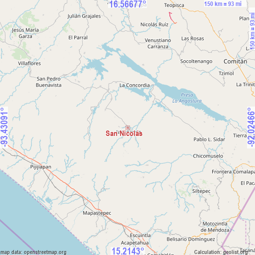
San Nicolás GPS coordinates[2]
15° 53' 30.012" North, 92° 43' 40.008" West
| Map corner | latitude | longitude |
|---|---|---|
| Upper-left | 16.56677°, | -93.43091° |
| Center: | 15.89167°, | -92.72778° |
| Lower-right: | 15.2143°, | -92.02466° |
| Map W x H: | 150.4×150.4 km | = 93.5×93.5mi |
| max Lat: | 32.7° ⇑97.6% North |
| San Nicolás: | 15.89167° |
| min Lat: | ⇓2.4% South 14.53588° |
| min Long | San Nicolás | max Long |
| -117.105° | -92.72778° | -86.73105° |
| W 90.3%⇐ | ⇒9.7% E |
Elevation
Elevation of San Nicolás is 620 m = 2034 ft, and this is 633.7 m = 2079 ft below average elevation for this country.
| Max E: |
3497 m = 11473 ft | 66.3% |
| Avg. | 1253.7 m = 4113 ft | |
| San Nicolás | 620 m = 2034 ft | |
Min E: |
-1 m = -3 ft | 33.7% |
See also: Mexico elevation on elevation.city.
Geographical zone
San Nicolás is located in North Torrid zone (between Equator and Tropic of Cancer). Distance of this Northern Tropic circle is 838.9 km =521.3 mi to North.| Distance of | km | miles | from San Nicolás |
|---|---|---|---|
| North Pole | 8240.1 | 5120.2 | to North |
| Arctic Circle | 5634.2 | 3500.9 | to North |
| Tropic Cancer | 838.9 | 521.3 | to North |
| Equator | 1767 | 1098 | to South |


Nearby cities:
15 places around San Nicolás: (largest is in red/bold)
• Benito Juárez
19.4 km =12.1 mi,  329°
329°
• Dolores Jaltenango
5.4 km =3.4 mi,  276°
276°
• Francisco I. Madero
8.7 km =5.4 mi,  148°
148°
• Ignacio Zaragoza
21.3 km =13.2 mi,  44°
44°
• Jaltenango de la Paz
2.1 km =1.3 mi,  169°
169°
• La Paz
16 km =9.9 mi,  139°
139°
• La Tigrilla
17.1 km =10.6 mi,  308°
308°
• Libertad del Pajal
14.7 km =9.1 mi, 149°
• Nueva Colombia
21.7 km =13.5 mi,  178°
178°
• Nueva Palestina
9.8 km =6.1 mi,  194°
194°
• Plan de la Libertad
21.9 km =13.6 mi,  232°
232°
• Querétaro
6.8 km =4.2 mi,  208°
208°
• Reforma
7.4 km =4.6 mi,  65°
65°
• Salvador Urbina
15.6 km =9.7 mi,  217°
217°
• Unión Buenavista
22.4 km =13.9 mi,  118°
118°
Sources, notices
• [Note1] Compared only with cities in Mexico existing in our database
• [Src1] Map data: © OpenStreetMap contributors (CC-BY-SA)
• [Src2] Other city data from geonames.org with taken over terms of usage.
• [Src3] Geographical zone / Annual Mean Temperature by Robert A. Rohde @ Wikipedia
