Benito Juárez geodata
Benito Juárez (Chiapas) is a populated place; located in Mexico in America/Mexico_City (GMT-6) time zone. With population of 2,715 people, there are 3257 cities with bigger population in this country. Compared to other cities in Mexico, 97.1% of cities are located further ↑North; 89.7% of cities are located further ←West and 67.3% of cities have higher elevation than Benito Juárez. Note1


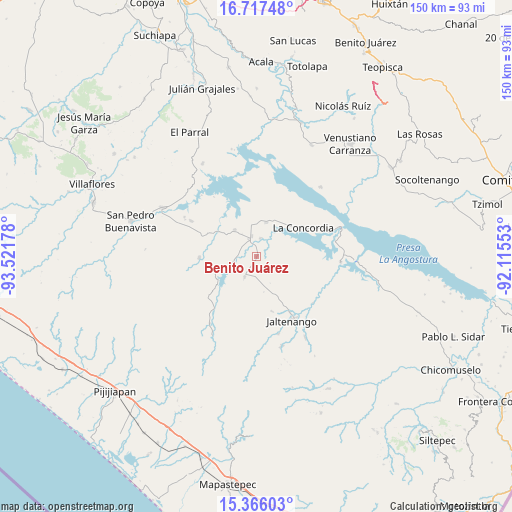
Benito Juárez GPS coordinates[2]
16° 2' 34.44" North, 92° 49' 7.14" West
| Map corner | latitude | longitude |
|---|---|---|
| Upper-left | 16.71748°, | -93.52178° |
| Center: | 16.0429°, | -92.81865° |
| Lower-right: | 15.36603°, | -92.11553° |
| Map W x H: | 150.3×150.3 km | = 93.4×93.4mi |
| max Lat: | 32.7° ⇑97.1% North |
| Benito Juárez: | 16.0429° |
| min Lat: | ⇓2.9% South 14.53588° |
| min Long | Benito Juárez | max Long |
| -117.105° | -92.81865° | -86.73105° |
| W 89.7%⇐ | ⇒10.3% E |
Elevation
Elevation of Benito Juárez is 568 m = 1864 ft, and this is 685.7 m = 2250 ft below average elevation for this country.
| Max E: |
3497 m = 11473 ft | 67.3% |
| Avg. | 1253.7 m = 4113 ft | |
| Benito Juárez | 568 m = 1864 ft | |
Min E: |
-1 m = -3 ft | 32.7% |
See also: Mexico elevation on elevation.city.
Geographical zone
Benito Juárez is located in North Torrid zone (between Equator and Tropic of Cancer). Distance of this Northern Tropic circle is 822.1 km =510.8 mi to North.| Distance of | km | miles | from Benito Juárez |
|---|---|---|---|
| North Pole | 8223.3 | 5109.7 | to North |
| Arctic Circle | 5617.4 | 3490.5 | to North |
| Tropic Cancer | 822.1 | 510.8 | to North |
| Equator | 1783.8 | 1108.4 | to South |


Nearby cities:
15 places around Benito Juárez: (largest is in red/bold)
• Diamante de Echeverría
10 km =6.2 mi,  319°
319°
• Dolores Jaltenango
16.8 km =10.4 mi,  164°
164°
• El Ámbar (El Ámbar de Echeverría)
6.2 km =3.9 mi,  345°
345°
• Embarcadero de Jericó (El Siglo)
21.6 km =13.4 mi, 324°
• Guadalupe Victoria
8.8 km =5.5 mi,  247°
247°
• Independencia
5.2 km =3.2 mi,  336°
336°
• Jaltenango de la Paz
21.4 km =13.3 mi,  151°
151°
• La Concordia
16.1 km =10 mi,  58°
58°
• La Tigrilla
7.1 km =4.4 mi,  210°
210°
• Niños Héroes
22.1 km =13.7 mi,  70°
70°
• Nueva Libertad
5.4 km =3.4 mi,  12°
12°
• Nuevo Vicente Guerrero
16.8 km =10.4 mi,  268°
268°
• Plan de Agua Prieta
10.2 km =6.3 mi,  16°
16°
• Reforma
21.4 km =13.3 mi,  129°
129°
• San Nicolás
19.4 km =12.1 mi, 149°
Sources, notices
• [Note1] Compared only with cities in Mexico existing in our database
• [Src1] Map data: © OpenStreetMap contributors (CC-BY-SA)
• [Src2] Other city data from geonames.org with taken over terms of usage.
• [Src3] Geographical zone / Annual Mean Temperature by Robert A. Rohde @ Wikipedia
