Reforma geodata
Reforma (Chiapas) is a populated place; located in Mexico in America/Mexico_City (GMT-6) time zone. With population of 1,148 people, there are 7555 cities with bigger population in this country. Compared to other cities in Mexico, 97.5% of cities are located further ↑North; 90.7% of cities are located further ←West and 67.1% of cities have higher elevation than Reforma. Note1


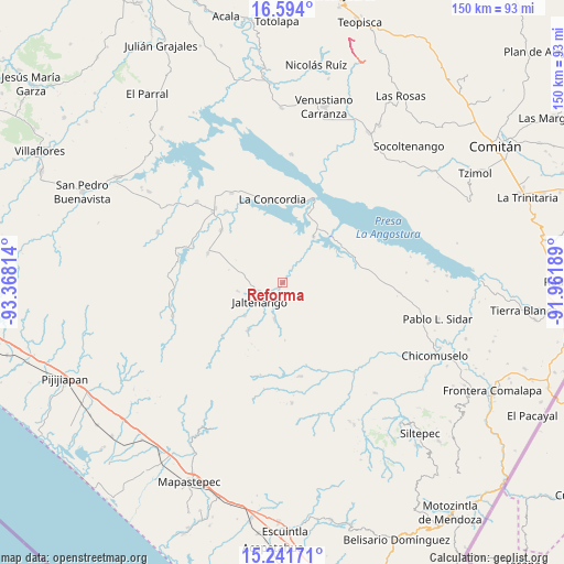
Reforma GPS coordinates[2]
15° 55' 8.364" North, 92° 39' 54.036" West
| Map corner | latitude | longitude |
|---|---|---|
| Upper-left | 16.594°, | -93.36814° |
| Center: | 15.91899°, | -92.66501° |
| Lower-right: | 15.24171°, | -91.96189° |
| Map W x H: | 150.4×150.4 km | = 93.5×93.5mi |
| max Lat: | 32.7° ⇑97.5% North |
| Reforma: | 15.91899° |
| min Lat: | ⇓2.5% South 14.53588° |
| min Long | Reforma | max Long |
| -117.105° | -92.66501° | -86.73105° |
| W 90.7%⇐ | ⇒9.3% E |
Elevation
Elevation of Reforma is 581 m = 1906 ft, and this is 672.7 m = 2207 ft below average elevation for this country.
| Max E: |
3497 m = 11473 ft | 67.1% |
| Avg. | 1253.7 m = 4113 ft | |
| Reforma | 581 m = 1906 ft | |
Min E: |
-1 m = -3 ft | 32.9% |
See also: Mexico elevation on elevation.city.
Geographical zone
Reforma is located in North Torrid zone (between Equator and Tropic of Cancer). Distance of this Northern Tropic circle is 835.9 km =519.4 mi to North.| Distance of | km | miles | from Reforma |
|---|---|---|---|
| North Pole | 8237 | 5118.2 | to North |
| Arctic Circle | 5631.1 | 3499 | to North |
| Tropic Cancer | 835.9 | 519.4 | to North |
| Equator | 1770 | 1099.8 | to South |


Nearby cities:
15 places around Reforma: (largest is in red/bold)
• Benito Juárez
21.4 km =13.3 mi,  309°
309°
• Dolores Jaltenango
12.3 km =7.6 mi,  258°
258°
• Francisco I. Madero
10.7 km =6.6 mi,  191°
191°
• Ignacio Zaragoza
14.6 km =9.1 mi,  34°
34°
• Jaltenango de la Paz
8.1 km =5 mi,  231°
231°
• La Concordia
22.3 km =13.9 mi,  353°
353°
• La Paz
15.7 km =9.8 mi,  166°
166°
• La Tigrilla
21.4 km =13.3 mi,  290°
290°
• Libertad del Pajal
15.8 km =9.8 mi,  177°
177°
• Niños Héroes
21.5 km =13.4 mi,  12°
12°
• Nueva Palestina
15.5 km =9.6 mi,  216°
216°
• Querétaro
13.4 km =8.3 mi, 227°
• Rizo de Oro
20.3 km =12.6 mi,  73°
73°
• San Nicolás
7.4 km =4.6 mi,  245°
245°
• Unión Buenavista
18.9 km =11.7 mi,  136°
136°
Sources, notices
• [Note1] Compared only with cities in Mexico existing in our database
• [Src1] Map data: © OpenStreetMap contributors (CC-BY-SA)
• [Src2] Other city data from geonames.org with taken over terms of usage.
• [Src3] Geographical zone / Annual Mean Temperature by Robert A. Rohde @ Wikipedia
