La Tigrilla geodata
La Tigrilla (Chiapas) is a populated place; located in Mexico in America/Mexico_City (GMT-6) time zone. With population of 2,346 people, there are 3763 cities with bigger population in this country. Compared to other cities in Mexico, 97.3% of cities are located further ↑North; 89.5% of cities are located further ←West and 66.7% of cities have higher elevation than La Tigrilla. Note1


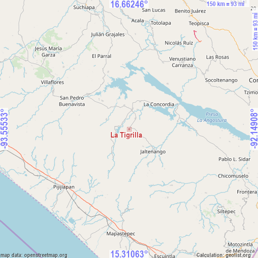
La Tigrilla GPS coordinates[2]
15° 59' 15.684" North, 92° 51' 7.92" West
| Map corner | latitude | longitude |
|---|---|---|
| Upper-left | 16.66246°, | -93.55533° |
| Center: | 15.98769°, | -92.8522° |
| Lower-right: | 15.31063°, | -92.14908° |
| Map W x H: | 150.3×150.3 km | = 93.4×93.4mi |
| max Lat: | 32.7° ⇑97.3% North |
| La Tigrilla: | 15.98769° |
| min Lat: | ⇓2.7% South 14.53588° |
| min Long | La Tigrilla | max Long |
| -117.105° | -92.8522° | -86.73105° |
| W 89.5%⇐ | ⇒10.5% E |
Elevation
Elevation of La Tigrilla is 599 m = 1965 ft, and this is 654.7 m = 2148 ft below average elevation for this country.
| Max E: |
3497 m = 11473 ft | 66.7% |
| Avg. | 1253.7 m = 4113 ft | |
| La Tigrilla | 599 m = 1965 ft | |
Min E: |
-1 m = -3 ft | 33.3% |
See also: Mexico elevation on elevation.city.
Geographical zone
La Tigrilla is located in North Torrid zone (between Equator and Tropic of Cancer). Distance of this Northern Tropic circle is 828.3 km =514.7 mi to North.| Distance of | km | miles | from La Tigrilla |
|---|---|---|---|
| North Pole | 8229.4 | 5113.5 | to North |
| Arctic Circle | 5623.5 | 3494.3 | to North |
| Tropic Cancer | 828.3 | 514.7 | to North |
| Equator | 1777.7 | 1104.6 | to South |


Nearby cities:
15 places around La Tigrilla: (largest is in red/bold)
• Benito Juárez
7.1 km =4.4 mi,  30°
30°
• Diamante de Echeverría
14.1 km =8.8 mi,  348°
348°
• Dolores Jaltenango
12.9 km =8 mi,  141°
141°
• El Ramal (Porvenir)
16.8 km =10.4 mi,  216°
216°
• El Ámbar (El Ámbar de Echeverría)
12.3 km =7.6 mi,  9°
9°
• Guadalupe Victoria
5.3 km =3.3 mi,  301°
301°
• Independencia
11 km =6.8 mi, 7°
• Jaltenango de la Paz
18.7 km =11.6 mi,  132°
132°
• La Concordia
22.6 km =14 mi,  50°
50°
• Nueva Libertad
12.4 km =7.7 mi,  22°
22°
• Nuevo Vicente Guerrero
14.3 km =8.9 mi,  293°
293°
• Plan de Agua Prieta
17.2 km =10.7 mi, 22°
• Querétaro
19.5 km =12.1 mi,  148°
148°
• Reforma
21.4 km =13.3 mi,  110°
110°
• San Nicolás
17.1 km =10.6 mi, 128°
Sources, notices
• [Note1] Compared only with cities in Mexico existing in our database
• [Src1] Map data: © OpenStreetMap contributors (CC-BY-SA)
• [Src2] Other city data from geonames.org with taken over terms of usage.
• [Src3] Geographical zone / Annual Mean Temperature by Robert A. Rohde @ Wikipedia
