La Rosa geodata
La Rosa (Veracruz) is a populated place; located in Mexico in America/Mexico_City (GMT-6) time zone. With population of 653 people, there are 13279 cities with bigger population in this country. Compared to other cities in Mexico, 66.8% of cities are located further ↑North; 72.3% of cities are located further ←West and 92.3% of cities have lower elevation than La Rosa. Note1


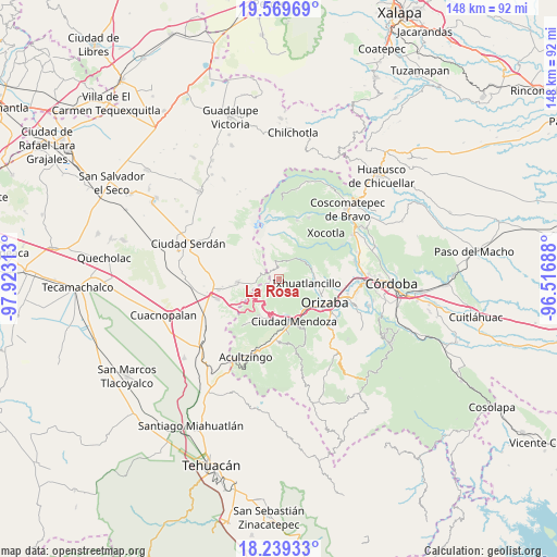
La Rosa GPS coordinates[2]
18° 54' 20.988" North, 97° 13' 12" West
| Map corner | latitude | longitude |
|---|---|---|
| Upper-left | 19.56969°, | -97.92313° |
| Center: | 18.90583°, | -97.22° |
| Lower-right: | 18.23933°, | -96.51688° |
| Map W x H: | 147.9×147.9 km | = 91.9×91.9mi |
| max Lat: | 32.7° ⇑66.8% North |
| La Rosa: | 18.90583° |
| min Lat: | ⇓33.2% South 14.53588° |
| min Long | La Rosa | max Long |
| -117.105° | -97.22° | -86.73105° |
| W 72.3%⇐ | ⇒27.7% E |
Elevation
Elevation of La Rosa is 2495 m = 8186 ft, and this is 1241.3 m = 4073 ft above average elevation for this country.
| Max E: |
3497 m = 11473 ft | 7.7% |
| La Rosa | 2495 m 8186 ft | |
| Avg. | 1253.7 m = 4113 ft | |
Min E: |
-1 m = -3 ft | 92.3% |
See also: Mexico elevation on elevation.city.
Geographical zone
La Rosa is located in North Torrid zone (between Equator and Tropic of Cancer). Distance of this Northern Tropic circle is 503.8 km =313 mi to North.| Distance of | km | miles | from La Rosa |
|---|---|---|---|
| North Pole | 7904.9 | 4911.9 | to North |
| Arctic Circle | 5299 | 3292.6 | to North |
| Tropic Cancer | 503.8 | 313 | to North |
| Equator | 2102.1 | 1306.2 | to South |


Nearby cities:
15 places around La Rosa: (largest is in red/bold)
• Agua Escondida
8 km =5 mi,  13°
13°
• El Lindero
8.5 km =5.3 mi,  39°
39°
• Frijolillo
5 km =3.1 mi,  20°
20°
• Ixhuatlancillo
7.5 km =4.7 mi,  96°
96°
• Loma Grande
2.2 km =1.4 mi,  328°
328°
• Papalotla
7.9 km =4.9 mi,  26°
26°
• Paso Carretas
3.7 km =2.3 mi,  295°
295°
• San Isidro el Berro
2.8 km =1.7 mi, 32°
• San José Súchil
2.7 km =1.7 mi,  222°
222°
• San Juan Huiloapan
6.5 km =4 mi,  259°
259°
• Santa Cruz Texmalaquilla
8.2 km =5.1 mi, 300°
• Texmalaca
6.7 km =4.2 mi, 37°
• Texmola
4.5 km =2.8 mi, 326°
• Xiquila
6.1 km =3.8 mi, 26°
• Xometla
8.4 km =5.2 mi, 24°
Sources, notices
• [Note1] Compared only with cities in Mexico existing in our database
• [Src1] Map data: © OpenStreetMap contributors (CC-BY-SA)
• [Src2] Other city data from geonames.org with taken over terms of usage.
• [Src3] Geographical zone / Annual Mean Temperature by Robert A. Rohde @ Wikipedia
