El Tule geodata
El Tule (Jalisco) is a populated place; located in Mexico in America/Mexico_City (GMT-6) time zone. With population of 645 people, there are 13413 cities with bigger population in this country. Compared to other cities in Mexico, 72% of cities are located further ↓South; 83.7% of cities are located further →East and 73.8% of cities have lower elevation than El Tule. Note1


El Tule GPS coordinates[2]
20° 43' 0.012" North, 102° 26' 26.988" West
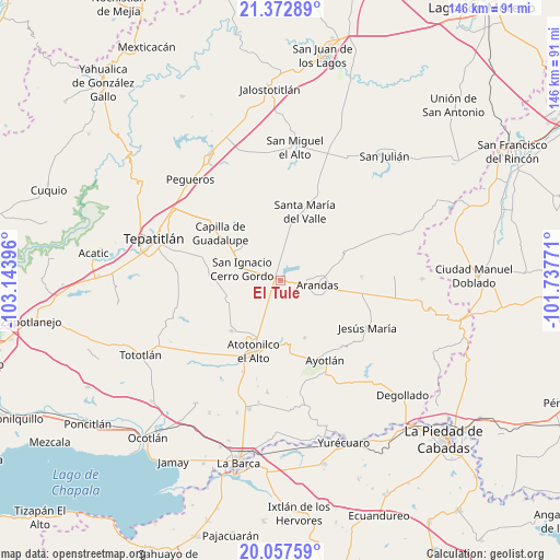
| Map corner | latitude | longitude |
|---|---|---|
| Upper-left | 21.37289°, | -103.14396° |
| Center: | 20.71667°, | -102.44083° |
| Lower-right: | 20.05759°, | -101.73771° |
| Map W x H: | 146.2×146.2 km | = 90.8×90.8mi |
| max Lat: | 32.7° ⇑28% North |
| El Tule: | 20.71667° |
| min Lat: | ⇓72% South 14.53588° |
| min Long | El Tule | max Long |
| -117.105° | -102.44083° | -86.73105° |
| W 16.3%⇐ | ⇒83.7% E |
Elevation
Elevation of El Tule is 2006 m = 6581 ft, and this is 752.3 m = 2468 ft above average elevation for this country.
| Max E: |
3497 m = 11473 ft | 26.2% |
| El Tule | 2006 m 6581 ft | |
| Avg. | 1253.7 m = 4113 ft | |
Min E: |
-1 m = -3 ft | 73.8% |
See also: Mexico elevation on elevation.city.
Geographical zone
El Tule is located in North Torrid zone (between Equator and Tropic of Cancer). Distance of this Northern Tropic circle is 302.4 km =187.9 mi to North.| Distance of | km | miles | from El Tule |
|---|---|---|---|
| North Pole | 7703.6 | 4786.8 | to North |
| Arctic Circle | 5097.7 | 3167.6 | to North |
| Tropic Cancer | 302.4 | 187.9 | to North |
| Equator | 2303.5 | 1431.3 | to South |


Nearby cities:
15 places around El Tule: (largest is in red/bold)
• Arandas
9.9 km =6.2 mi,  97°
97°
• Atotonilco el Alto
19.8 km =12.3 mi,  201°
201°
• Betania
16.3 km =10.1 mi,  156°
156°
• Capilla de Guadalupe
20 km =12.4 mi,  308°
308°
• Cañada de San Ignacio
20.4 km =12.7 mi,  153°
153°
• La Palma (La Angostura)
16.4 km =10.2 mi,  173°
173°
• La Trinidad
6.2 km =3.9 mi,  222°
222°
• Las Palmas
17.8 km =11.1 mi,  194°
194°
• Los Dolores
13.5 km =8.4 mi,  316°
316°
• Ojo de Agua de Morán
16.4 km =10.2 mi,  214°
214°
• Rinconada de los Vázquez [Fraccionamiento]
7.2 km =4.5 mi,  92°
92°
• San Francisco de Asís
18.5 km =11.5 mi, 223°
• San Ignacio Cerro Gordo
10.3 km =6.4 mi,  288°
288°
• San José de Gracia
14.2 km =8.8 mi,  250°
250°
• Santa María del Valle
19.1 km =11.9 mi,  19°
19°
Sources, notices
• [Note1] Compared only with cities in Mexico existing in our database
• [Src1] Map data: © OpenStreetMap contributors (CC-BY-SA)
• [Src2] Other city data from geonames.org with taken over terms of usage.
• [Src3] Geographical zone / Annual Mean Temperature by Robert A. Rohde @ Wikipedia
