Los Dolores geodata
Los Dolores (Jalisco) is a populated place; located in Mexico in America/Mexico_City (GMT-6) time zone. With population of 864 people, there are 10127 cities with bigger population in this country. Compared to other cities in Mexico, 73.4% of cities are located further ↓South; 84.2% of cities are located further →East and 77% of cities have lower elevation than Los Dolores. Note1


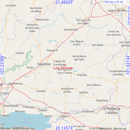
Los Dolores GPS coordinates[2]
20° 48' 15.984" North, 102° 31' 50.016" West
| Map corner | latitude | longitude |
|---|---|---|
| Upper-left | 21.46028°, | -103.23369° |
| Center: | 20.80444°, | -102.53056° |
| Lower-right: | 20.14574°, | -101.82744° |
| Map W x H: | 146.2×146.2 km | = 90.8×90.8mi |
| max Lat: | 32.7° ⇑26.6% North |
| Los Dolores: | 20.80444° |
| min Lat: | ⇓73.4% South 14.53588° |
| min Long | Los Dolores | max Long |
| -117.105° | -102.53056° | -86.73105° |
| W 15.8%⇐ | ⇒84.2% E |
Elevation
Elevation of Los Dolores is 2068 m = 6785 ft, and this is 814.3 m = 2672 ft above average elevation for this country.
| Max E: |
3497 m = 11473 ft | 23% |
| Los Dolores | 2068 m 6785 ft | |
| Avg. | 1253.7 m = 4113 ft | |
Min E: |
-1 m = -3 ft | 77% |
See also: Mexico elevation on elevation.city.
Geographical zone
Los Dolores is located in North Torrid zone (between Equator and Tropic of Cancer). Distance of this Northern Tropic circle is 292.7 km =181.9 mi to North.| Distance of | km | miles | from Los Dolores |
|---|---|---|---|
| North Pole | 7693.8 | 4780.7 | to North |
| Arctic Circle | 5087.9 | 3161.5 | to North |
| Tropic Cancer | 292.7 | 181.9 | to North |
| Equator | 2313.2 | 1437.4 | to South |


Nearby cities:
15 places around Los Dolores: (largest is in red/bold)
• Arandas
22.1 km =13.7 mi,  119°
119°
• Capilla de Guadalupe
6.9 km =4.3 mi,  291°
291°
• El Tule
13.5 km =8.4 mi,  136°
136°
• La Loma (Loma de Enmedio)
21.7 km =13.5 mi,  268°
268°
• La Trinidad
15.2 km =9.4 mi,  160°
160°
• Ojo de Agua de Latillas
22.7 km =14.1 mi,  228°
228°
• Ojo de Agua de Morán
23.3 km =14.5 mi,  179°
179°
• Pegueros
21.9 km =13.6 mi,  319°
319°
• Rinconada de los Vázquez [Fraccionamiento]
19.4 km =12.1 mi, 121°
• San Francisco de Asís
23.3 km =14.5 mi,  188°
188°
• San Ignacio Cerro Gordo
6.6 km =4.1 mi, 183°
• San José de Gracia
15 km =9.3 mi,  195°
195°
• Santa María del Valle
17.7 km =11 mi,  62°
62°
• Tepatitlán de Morelos
24.2 km =15 mi, 273°
• Valle de Guadalupe
24.7 km =15.3 mi,  338°
338°
Sources, notices
• [Note1] Compared only with cities in Mexico existing in our database
• [Src1] Map data: © OpenStreetMap contributors (CC-BY-SA)
• [Src2] Other city data from geonames.org with taken over terms of usage.
• [Src3] Geographical zone / Annual Mean Temperature by Robert A. Rohde @ Wikipedia
