Suyalhó geodata
Suyalhó (Chiapas) is a populated place; located in Mexico in America/Mexico_City (GMT-6) time zone. With population of 644 people, there are 13427 cities with bigger population in this country. Compared to other cities in Mexico, 90.6% of cities are located further ↑North; 91.3% of cities are located further ←West and 75.6% of cities have lower elevation than Suyalhó. Note1


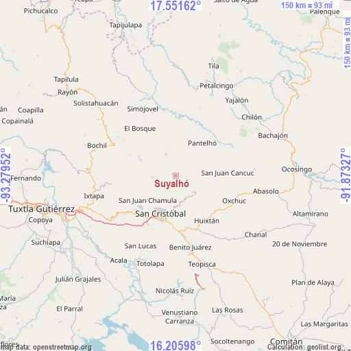
Suyalhó GPS coordinates[2]
16° 52' 48" North, 92° 34' 35.004" West
| Map corner | latitude | longitude |
|---|---|---|
| Upper-left | 17.55162°, | -93.27952° |
| Center: | 16.88°, | -92.57639° |
| Lower-right: | 16.20598°, | -91.87327° |
| Map W x H: | 149.6×149.6 km | = 93×93mi |
| max Lat: | 32.7° ⇑90.6% North |
| Suyalhó: | 16.88° |
| min Lat: | ⇓9.4% South 14.53588° |
| min Long | Suyalhó | max Long |
| -117.105° | -92.57639° | -86.73105° |
| W 91.3%⇐ | ⇒8.7% E |
Elevation
Elevation of Suyalhó is 2040 m = 6693 ft, and this is 786.3 m = 2580 ft above average elevation for this country.
| Max E: |
3497 m = 11473 ft | 24.4% |
| Suyalhó | 2040 m 6693 ft | |
| Avg. | 1253.7 m = 4113 ft | |
Min E: |
-1 m = -3 ft | 75.6% |
See also: Mexico elevation on elevation.city.
Geographical zone
Suyalhó is located in North Torrid zone (between Equator and Tropic of Cancer). Distance of this Northern Tropic circle is 729 km =453 mi to North.| Distance of | km | miles | from Suyalhó |
|---|---|---|---|
| North Pole | 8130.2 | 5051.9 | to North |
| Arctic Circle | 5524.3 | 3432.6 | to North |
| Tropic Cancer | 729 | 453 | to North |
| Equator | 1876.9 | 1166.3 | to South |


Nearby cities:
15 places around Suyalhó: (largest is in red/bold)
• Bashequen
3.6 km =2.2 mi,  277°
277°
• Chalam
2.9 km =1.8 mi,  72°
72°
• Chicumtantic
3.5 km =2.2 mi,  242°
242°
• Chimhucum
4.9 km =3 mi,  76°
76°
• Cuchumtón
1.2 km =0.7 mi,  225°
225°
• El Pozo
3.2 km =2 mi,  171°
171°
• La Libertad
2.9 km =1.8 mi,  20°
20°
• Oxinam
3.5 km =2.2 mi,  123°
123°
• Pajaltón Bajo
5.2 km =3.2 mi,  150°
150°
• Pulumsibac
4.4 km =2.7 mi,  87°
87°
• Titaltetic
2.3 km =1.4 mi,  110°
110°
• Tojtic
2.6 km =1.6 mi, 68°
• Tzoeptic
0.9 km =0.6 mi, 70°
• Tzontehuitz
5.2 km =3.2 mi,  183°
183°
• Yaxalumil
4.3 km =2.7 mi,  359°
359°
Sources, notices
• [Note1] Compared only with cities in Mexico existing in our database
• [Src1] Map data: © OpenStreetMap contributors (CC-BY-SA)
• [Src2] Other city data from geonames.org with taken over terms of usage.
• [Src3] Geographical zone / Annual Mean Temperature by Robert A. Rohde @ Wikipedia
