La Libertad geodata
La Libertad (Chiapas) is a populated place; located in Mexico in America/Mexico_City (GMT-6) time zone. With population of 897 people, there are 9721 cities with bigger population in this country. Compared to other cities in Mexico, 90.2% of cities are located further ↑North; 91.4% of cities are located further ←West and 66.7% of cities have lower elevation than La Libertad. Note1


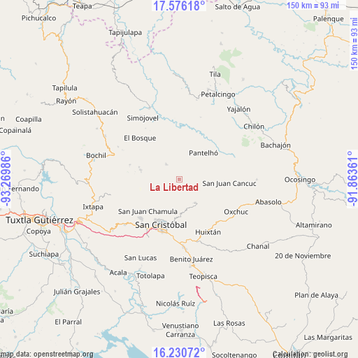
La Libertad GPS coordinates[2]
16° 54' 16.74" North, 92° 34' 0.228" West
| Map corner | latitude | longitude |
|---|---|---|
| Upper-left | 17.57618°, | -93.26986° |
| Center: | 16.90465°, | -92.56673° |
| Lower-right: | 16.23072°, | -91.86361° |
| Map W x H: | 149.6×149.6 km | = 93×93mi |
| max Lat: | 32.7° ⇑90.2% North |
| La Libertad: | 16.90465° |
| min Lat: | ⇓9.8% South 14.53588° |
| min Long | La Libertad | max Long |
| -117.105° | -92.56673° | -86.73105° |
| W 91.4%⇐ | ⇒8.6% E |
Elevation
Elevation of La Libertad is 1863 m = 6112 ft, and this is 609.3 m = 1999 ft above average elevation for this country.
| Max E: |
3497 m = 11473 ft | 33.3% |
| La Libertad | 1863 m 6112 ft | |
| Avg. | 1253.7 m = 4113 ft | |
Min E: |
-1 m = -3 ft | 66.7% |
See also: Mexico elevation on elevation.city.
Geographical zone
La Libertad is located in North Torrid zone (between Equator and Tropic of Cancer). Distance of this Northern Tropic circle is 726.3 km =451.3 mi to North.| Distance of | km | miles | from La Libertad |
|---|---|---|---|
| North Pole | 8127.4 | 5050.1 | to North |
| Arctic Circle | 5521.6 | 3431 | to North |
| Tropic Cancer | 726.3 | 451.3 | to North |
| Equator | 1879.6 | 1167.9 | to South |


Nearby cities:
15 places around La Libertad: (largest is in red/bold)
• Alamul
4.8 km =3 mi,  115°
115°
• Bashequen
5.1 km =3.2 mi,  244°
244°
• Chalam
2.6 km =1.6 mi,  136°
136°
• Chimhucum
4.1 km =2.5 mi,  113°
113°
• Cuchumtón
4.1 km =2.5 mi,  207°
207°
• El Pozo
5.9 km =3.7 mi,  185°
185°
• Oxinam
5 km =3.1 mi,  158°
158°
• Pulumsibac
4.3 km =2.7 mi,  126°
126°
• Suyalhó
2.9 km =1.8 mi,  200°
200°
• Titaltetic
3.7 km =2.3 mi, 162°
• Tojtic
2.3 km =1.4 mi, 143°
• Tzoeptic
2.4 km =1.5 mi,  183°
183°
• Yabteclum (Pueblo Viejo)
3.9 km =2.4 mi,  358°
358°
• Yabteclum Fracción Dos
2.9 km =1.8 mi,  11°
11°
• Yaxalumil
1.9 km =1.2 mi,  325°
325°
Sources, notices
• [Note1] Compared only with cities in Mexico existing in our database
• [Src1] Map data: © OpenStreetMap contributors (CC-BY-SA)
• [Src2] Other city data from geonames.org with taken over terms of usage.
• [Src3] Geographical zone / Annual Mean Temperature by Robert A. Rohde @ Wikipedia
