Oxinam geodata
Oxinam (Chiapas) is a populated place; located in Mexico in America/Mexico_City (GMT-6) time zone. With population of 1,033 people, there are 8436 cities with bigger population in this country. Compared to other cities in Mexico, 90.9% of cities are located further ↑North; 91.5% of cities are located further ←West and 75% of cities have lower elevation than Oxinam. Note1


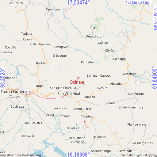
Oxinam GPS coordinates[2]
16° 51' 47.016" North, 92° 32' 57.012" West
| Map corner | latitude | longitude |
|---|---|---|
| Upper-left | 17.53474°, | -93.2523° |
| Center: | 16.86306°, | -92.54917° |
| Lower-right: | 16.18899°, | -91.84605° |
| Map W x H: | 149.6×149.6 km | = 93×93mi |
| max Lat: | 32.7° ⇑90.9% North |
| Oxinam: | 16.86306° |
| min Lat: | ⇓9.1% South 14.53588° |
| min Long | Oxinam | max Long |
| -117.105° | -92.54917° | -86.73105° |
| W 91.5%⇐ | ⇒8.5% E |
Elevation
Elevation of Oxinam is 2031 m = 6663 ft, and this is 777.3 m = 2550 ft above average elevation for this country.
| Max E: |
3497 m = 11473 ft | 25% |
| Oxinam | 2031 m 6663 ft | |
| Avg. | 1253.7 m = 4113 ft | |
Min E: |
-1 m = -3 ft | 75% |
See also: Mexico elevation on elevation.city.
Geographical zone
Oxinam is located in North Torrid zone (between Equator and Tropic of Cancer). Distance of this Northern Tropic circle is 730.9 km =454.2 mi to North.| Distance of | km | miles | from Oxinam |
|---|---|---|---|
| North Pole | 8132.1 | 5053.1 | to North |
| Arctic Circle | 5526.2 | 3433.8 | to North |
| Tropic Cancer | 730.9 | 454.2 | to North |
| Equator | 1875 | 1165.1 | to South |


Nearby cities:
15 places around Oxinam: (largest is in red/bold)
• Alamul
3.5 km =2.2 mi,  44°
44°
• Chalam
2.7 km =1.7 mi,  357°
357°
• Chimhucum
3.5 km =2.2 mi,  32°
32°
• Cuchumtón
3.9 km =2.4 mi,  284°
284°
• El Pozo
2.7 km =1.7 mi,  242°
242°
• La Libertad
5 km =3.1 mi,  338°
338°
• Pajaltón
3.7 km =2.3 mi,  148°
148°
• Pajaltón Alto
4.5 km =2.8 mi,  213°
213°
• Pajaltón Bajo
2.7 km =1.7 mi,  186°
186°
• Pulumsibac
2.6 km =1.6 mi, 36°
• Suyalhó
3.5 km =2.2 mi,  303°
303°
• Titaltetic
1.3 km =0.8 mi,  324°
324°
• Tojtic
2.9 km =1.8 mi,  349°
349°
• Tzoeptic
3 km =1.9 mi, 317°
• Tzontehuitz
4.6 km =2.9 mi,  224°
224°
Sources, notices
• [Note1] Compared only with cities in Mexico existing in our database
• [Src1] Map data: © OpenStreetMap contributors (CC-BY-SA)
• [Src2] Other city data from geonames.org with taken over terms of usage.
• [Src3] Geographical zone / Annual Mean Temperature by Robert A. Rohde @ Wikipedia
