Canícuaro geodata
Canícuaro (Michoacán) is a populated place; located in Mexico in America/Mexico_City (GMT-6) time zone. With population of 641 people, there are 13506 cities with bigger population in this country. Compared to other cities in Mexico, 60.3% of cities are located further ↑North; 76.8% of cities are located further →East and 52.1% of cities have lower elevation than Canícuaro. Note1


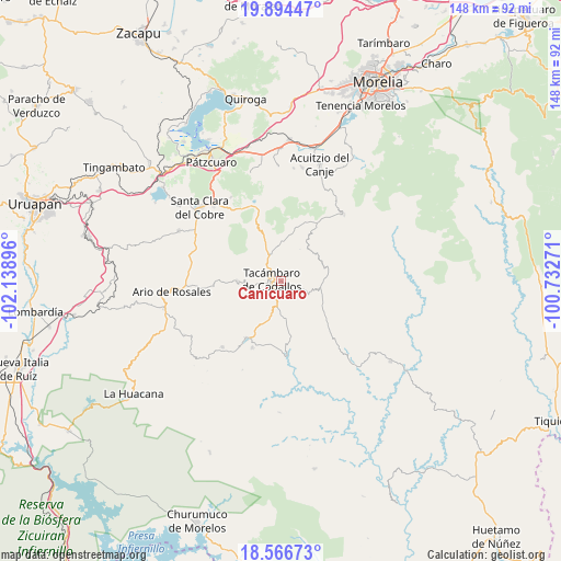
Canícuaro GPS coordinates[2]
19° 13' 54.984" North, 101° 26' 8.988" West
| Map corner | latitude | longitude |
|---|---|---|
| Upper-left | 19.89447°, | -102.13896° |
| Center: | 19.23194°, | -101.43583° |
| Lower-right: | 18.56673°, | -100.73271° |
| Map W x H: | 147.6×147.6 km | = 91.7×91.7mi |
| max Lat: | 32.7° ⇑60.3% North |
| Canícuaro: | 19.23194° |
| min Lat: | ⇓39.7% South 14.53588° |
| min Long | Canícuaro | max Long |
| -117.105° | -101.43583° | -86.73105° |
| W 23.2%⇐ | ⇒76.8% E |
Elevation
Elevation of Canícuaro is 1526 m = 5007 ft, and this is 272.3 m = 893 ft above average elevation for this country.
| Max E: |
3497 m = 11473 ft | 47.9% |
| Canícuaro | 1526 m 5007 ft | |
| Avg. | 1253.7 m = 4113 ft | |
Min E: |
-1 m = -3 ft | 52.1% |
See also: Mexico elevation on elevation.city.
Geographical zone
Canícuaro is located in North Torrid zone (between Equator and Tropic of Cancer). Distance of this Northern Tropic circle is 467.5 km =290.5 mi to North.| Distance of | km | miles | from Canícuaro |
|---|---|---|---|
| North Pole | 7868.7 | 4889.4 | to North |
| Arctic Circle | 5262.8 | 3270.2 | to North |
| Tropic Cancer | 467.5 | 290.5 | to North |
| Equator | 2138.4 | 1328.7 | to South |


Nearby cities:
15 places around Canícuaro: (largest is in red/bold)
• Chupio
6.1 km =3.8 mi,  190°
190°
• Cópitero
9.8 km =6.1 mi,  31°
31°
• El Terrero
9.3 km =5.8 mi,  268°
268°
• La Loma
5.7 km =3.5 mi,  162°
162°
• La Viña
5.1 km =3.2 mi,  316°
316°
• Las Hoyas Altas
1.5 km =0.9 mi,  86°
86°
• Las Joyas (El Poblado)
2.9 km =1.8 mi,  171°
171°
• Ojo de Agua de Chupio
10.5 km =6.5 mi, 172°
• Pedernales
10.7 km =6.6 mi,  199°
199°
• San Miguel Tamácuaro
1.4 km =0.9 mi,  348°
348°
• San Rafael Tecario
7.8 km =4.8 mi,  252°
252°
• Santas Marías
9.8 km =6.1 mi,  286°
286°
• Serrano
9 km =5.6 mi,  303°
303°
• Tacámbaro de Codallos
2.4 km =1.5 mi,  278°
278°
• Testerazo
2.9 km =1.8 mi, 302°
Sources, notices
• [Note1] Compared only with cities in Mexico existing in our database
• [Src1] Map data: © OpenStreetMap contributors (CC-BY-SA)
• [Src2] Other city data from geonames.org with taken over terms of usage.
• [Src3] Geographical zone / Annual Mean Temperature by Robert A. Rohde @ Wikipedia
