San Miguel Tamácuaro geodata
San Miguel Tamácuaro (Michoacán) is a populated place; located in Mexico in America/Mexico_City (GMT-6) time zone. With population of 811 people, there are 10778 cities with bigger population in this country. Compared to other cities in Mexico, 60% of cities are located further ↑North; 76.9% of cities are located further →East and 55.7% of cities have lower elevation than San Miguel Tamácuaro. Note1
Current local time in San Miguel Tamácuaro:
05:27 AM, WednesdayDifference from your time zone: hours


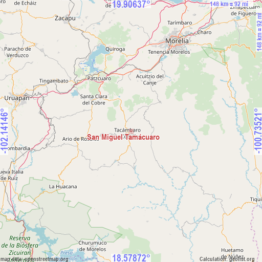
San Miguel Tamácuaro GPS coordinates[2]
19° 14' 38.004" North, 101° 26' 17.988" West
| Map corner | latitude | longitude |
|---|---|---|
| Upper-left | 19.90637°, | -102.14146° |
| Center: | 19.24389°, | -101.43833° |
| Lower-right: | 18.57872°, | -100.73521° |
| Map W x H: | 147.6×147.6 km | = 91.7×91.7mi |
| max Lat: | 32.7° ⇑60% North |
| San Miguel Tamácuaro: | 19.24389° |
| min Lat: | ⇓40% South 14.53588° |
| min Long | San Miguel Tam� | max Long |
| -117.105° | -101.43833° | -86.73105° |
| W 23.1%⇐ | ⇒76.9% E |
Elevation
Elevation of San Miguel Tamácuaro is 1607 m = 5272 ft, and this is 353.3 m = 1159 ft above average elevation for this country.
| Max E: |
3497 m = 11473 ft | 44.3% |
| San Miguel Tamácuaro | 1607 m 5272 ft | |
| Avg. | 1253.7 m = 4113 ft | |
Min E: |
-1 m = -3 ft | 55.7% |
See also: Mexico elevation on elevation.city.
Geographical zone
San Miguel Tamácuaro is located in North Torrid zone (between Equator and Tropic of Cancer). Distance of this Northern Tropic circle is 466.2 km =289.7 mi to North.| Distance of | km | miles | from San Miguel Tamácuaro |
|---|---|---|---|
| North Pole | 7867.3 | 4888.5 | to North |
| Arctic Circle | 5261.5 | 3269.3 | to North |
| Tropic Cancer | 466.2 | 289.7 | to North |
| Equator | 2139.7 | 1329.5 | to South |


Nearby cities:
15 places around San Miguel Tamácuaro: (largest is in red/bold)
• Canícuaro
1.4 km =0.9 mi,  168°
168°
• Chupio
7.3 km =4.5 mi,  186°
186°
• Cópitero
8.9 km =5.5 mi,  37°
37°
• El Terrero
9.1 km =5.7 mi,  260°
260°
• La Loma
7 km =4.3 mi,  163°
163°
• La Viña
4 km =2.5 mi,  306°
306°
• Las Hoyas Altas
2.2 km =1.4 mi,  124°
124°
• Las Joyas (El Poblado)
4.3 km =2.7 mi, 170°
• San José de los Laureles
10.6 km =6.6 mi,  347°
347°
• San Rafael Tecario
8 km =5 mi,  242°
242°
• Santas Marías
9.2 km =5.7 mi,  278°
278°
• Serrano
8.1 km =5 mi,  296°
296°
• Tacámbaro de Codallos
2.3 km =1.4 mi, 244°
• Testerazo
2.2 km =1.4 mi, 275°
• Yoricostio (La Villita)
11.1 km =6.9 mi,  14°
14°
Sources, notices
• [Note1] Compared only with cities in Mexico existing in our database
• [Src1] Map data: © OpenStreetMap contributors (CC-BY-SA)
• [Src2] Other city data from geonames.org with taken over terms of usage.
• [Src3] Geographical zone / Annual Mean Temperature by Robert A. Rohde @ Wikipedia
