Bellavista del Norte geodata
Bellavista del Norte (Chiapas) is a populated place; located in Mexico in America/Mexico_City (GMT-6) time zone. With population of 636 people, there are 13615 cities with bigger population in this country. Compared to other cities in Mexico, 98.2% of cities are located further ↑North; 94.5% of cities are located further ←West and 65.5% of cities have higher elevation than Bellavista del Norte. Note1


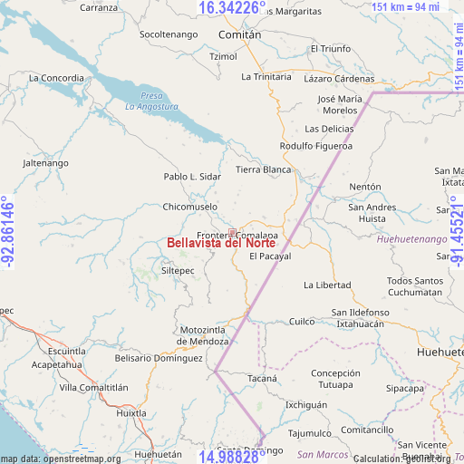
Bellavista del Norte GPS coordinates[2]
15° 39' 59.004" North, 92° 9' 29.988" West
| Map corner | latitude | longitude |
|---|---|---|
| Upper-left | 16.34226°, | -92.86146° |
| Center: | 15.66639°, | -92.15833° |
| Lower-right: | 14.98828°, | -91.45521° |
| Map W x H: | 150.5×150.6 km | = 93.5×93.6mi |
| max Lat: | 32.7° ⇑98.2% North |
| Bellavista del Norte: | 15.66639° |
| min Lat: | ⇓1.8% South 14.53588° |
| min Long | Bellavista del | max Long |
| -117.105° | -92.15833° | -86.73105° |
| W 94.5%⇐ | ⇒5.5% E |
Elevation
Elevation of Bellavista del Norte is 661 m = 2169 ft, and this is 592.7 m = 1945 ft below average elevation for this country.
| Max E: |
3497 m = 11473 ft | 65.5% |
| Avg. | 1253.7 m = 4113 ft | |
| Bellavista del Norte | 661 m = 2169 ft | |
Min E: |
-1 m = -3 ft | 34.5% |
See also: Mexico elevation on elevation.city.
Geographical zone
Bellavista del Norte is located in North Torrid zone (between Equator and Tropic of Cancer). Distance of this Northern Tropic circle is 864 km =536.9 mi to North.| Distance of | km | miles | from Bellavista del Norte |
|---|---|---|---|
| North Pole | 8265.1 | 5135.7 | to North |
| Arctic Circle | 5659.2 | 3516.5 | to North |
| Tropic Cancer | 864 | 536.9 | to North |
| Equator | 1741.9 | 1082.4 | to South |


Nearby cities:
15 places around Bellavista del Norte: (largest is in red/bold)
• Agua Zarca
3.9 km =2.4 mi,  157°
157°
• Comalapa
1.9 km =1.2 mi,  114°
114°
• El Anonal
3.9 km =2.4 mi,  52°
52°
• El Portal
6.8 km =4.2 mi,  79°
79°
• El Triunfo de las Tres Maravillas
2.2 km =1.4 mi,  174°
174°
• Guadalupe Grijalva
3.7 km =2.3 mi,  350°
350°
• La Lima
3.1 km =1.9 mi,  94°
94°
• La Reforma
7.1 km =4.4 mi,  312°
312°
• La Sabinada
2.9 km =1.8 mi,  11°
11°
• Las Chicharras
5.6 km =3.5 mi,  275°
275°
• Nueva Morelia
5.6 km =3.5 mi, 165°
• Nuevo México
6.5 km =4 mi,  69°
69°
• San José las Chicharras
5.8 km =3.6 mi,  243°
243°
• Santa Rosa
8.6 km =5.3 mi,  42°
42°
• Veinticuatro de Febrero
5.8 km =3.6 mi,  331°
331°
Sources, notices
• [Note1] Compared only with cities in Mexico existing in our database
• [Src1] Map data: © OpenStreetMap contributors (CC-BY-SA)
• [Src2] Other city data from geonames.org with taken over terms of usage.
• [Src3] Geographical zone / Annual Mean Temperature by Robert A. Rohde @ Wikipedia
