Guadalupe Grijalva geodata
Guadalupe Grijalva (Chiapas) is a populated place; located in Mexico in America/Mexico_City (GMT-6) time zone. With population of 1,034 people, there are 8428 cities with bigger population in this country. Compared to other cities in Mexico, 98.1% of cities are located further ↑North; 94.4% of cities are located further ←West and 66% of cities have higher elevation than Guadalupe Grijalva. Note1


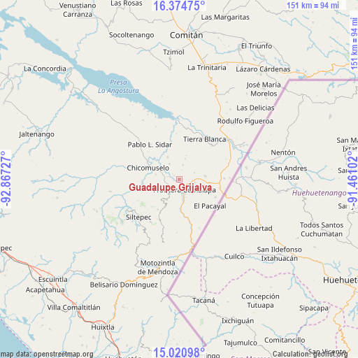
Guadalupe Grijalva GPS coordinates[2]
15° 41' 56.364" North, 92° 9' 50.904" West
| Map corner | latitude | longitude |
|---|---|---|
| Upper-left | 16.37475°, | -92.86727° |
| Center: | 15.69899°, | -92.16414° |
| Lower-right: | 15.02098°, | -91.46102° |
| Map W x H: | 150.5×150.5 km | = 93.5×93.5mi |
| max Lat: | 32.7° ⇑98.1% North |
| Guadalupe Grijalva: | 15.69899° |
| min Lat: | ⇓1.9% South 14.53588° |
| min Long | Guadalupe Grija | max Long |
| -117.105° | -92.16414° | -86.73105° |
| W 94.4%⇐ | ⇒5.6% E |
Elevation
Elevation of Guadalupe Grijalva is 634 m = 2080 ft, and this is 619.7 m = 2033 ft below average elevation for this country.
| Max E: |
3497 m = 11473 ft | 66% |
| Avg. | 1253.7 m = 4113 ft | |
| Guadalupe Grijalva | 634 m = 2080 ft | |
Min E: |
-1 m = -3 ft | 34% |
See also: Mexico elevation on elevation.city.
Geographical zone
Guadalupe Grijalva is located in North Torrid zone (between Equator and Tropic of Cancer). Distance of this Northern Tropic circle is 860.4 km =534.6 mi to North.| Distance of | km | miles | from Guadalupe Grijalva |
|---|---|---|---|
| North Pole | 8261.5 | 5133.5 | to North |
| Arctic Circle | 5655.6 | 3514.2 | to North |
| Tropic Cancer | 860.4 | 534.6 | to North |
| Equator | 1745.6 | 1084.7 | to South |


Nearby cities:
15 places around Guadalupe Grijalva: (largest is in red/bold)
• Agua Zarca
7.5 km =4.7 mi,  163°
163°
• Bellavista del Norte
3.7 km =2.3 mi,  170°
170°
• Comalapa
5 km =3.1 mi,  152°
152°
• Costa Rica
6 km =3.7 mi,  14°
14°
• El Anonal
3.9 km =2.4 mi,  107°
107°
• El Portal
7.7 km =4.8 mi, 108°
• El Triunfo de las Tres Maravillas
5.8 km =3.6 mi, 171°
• La Lima
5.4 km =3.4 mi,  136°
136°
• La Reforma
4.7 km =2.9 mi,  283°
283°
• La Sabinada
1.4 km =0.9 mi,  122°
122°
• Las Chicharras
5.9 km =3.7 mi,  237°
237°
• Nueva Libertad
7.5 km =4.7 mi,  328°
328°
• Nuevo México
6.8 km =4.2 mi,  101°
101°
• Santa Rosa
7 km =4.3 mi,  66°
66°
• Veinticuatro de Febrero
2.6 km =1.6 mi,  303°
303°
Sources, notices
• [Note1] Compared only with cities in Mexico existing in our database
• [Src1] Map data: © OpenStreetMap contributors (CC-BY-SA)
• [Src2] Other city data from geonames.org with taken over terms of usage.
• [Src3] Geographical zone / Annual Mean Temperature by Robert A. Rohde @ Wikipedia
