Xiloxúchitl geodata
Xiloxúchitl (Veracruz) is a populated place; located in Mexico in America/Mexico_City (GMT-6) time zone. With population of 574 people, there are 14926 cities with bigger population in this country. Compared to other cities in Mexico, 80.4% of cities are located further ↓South; 60.3% of cities are located further ←West and 74.2% of cities have higher elevation than Xiloxúchitl. Note1


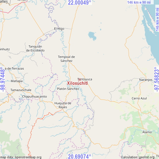
Xiloxúchitl GPS coordinates[2]
21° 20' 49.488" North, 98° 16' 16.86" West
| Map corner | latitude | longitude |
|---|---|---|
| Upper-left | 22.00049°, | -98.97448° |
| Center: | 21.34708°, | -98.27135° |
| Lower-right: | 20.69074°, | -97.56823° |
| Map W x H: | 145.6×145.6 km | = 90.5×90.5mi |
| max Lat: | 32.7° ⇑19.6% North |
| Xiloxúchitl: | 21.34708° |
| min Lat: | ⇓80.4% South 14.53588° |
| min Long | Xiloxúchitl | max Long |
| -117.105° | -98.27135° | -86.73105° |
| W 60.3%⇐ | ⇒39.7% E |
Elevation
Elevation of Xiloxúchitl is 248 m = 814 ft, and this is 1005.7 m = 3300 ft below average elevation for this country.
| Max E: |
3497 m = 11473 ft | 74.2% |
| Avg. | 1253.7 m = 4113 ft | |
| Xiloxúchitl | 248 m = 814 ft | |
Min E: |
-1 m = -3 ft | 25.8% |
See also: Mexico elevation on elevation.city.
Geographical zone
Xiloxúchitl is located in North Torrid zone (between Equator and Tropic of Cancer). Distance of this Northern Tropic circle is 232.3 km =144.3 mi to North.| Distance of | km | miles | from Xiloxúchitl |
|---|---|---|---|
| North Pole | 7633.5 | 4743.2 | to North |
| Arctic Circle | 5027.6 | 3124 | to North |
| Tropic Cancer | 232.3 | 144.3 | to North |
| Equator | 2373.6 | 1474.9 | to South |


Nearby cities:
15 places around Xiloxúchitl: (largest is in red/bold)
• Cerro Botica
7.1 km =4.4 mi,  4°
4°
• Ciruelar Aquiche
7.8 km =4.8 mi,  325°
325°
• Cuchilla Chica
9.1 km =5.7 mi,  342°
342°
• El Jobo Aquiche
5.7 km =3.5 mi, 326°
• El Lindero
6.5 km =4 mi,  125°
125°
• La Estanzuela
7.3 km =4.5 mi,  348°
348°
• Mezquite Mata del Tigre
7.8 km =4.8 mi,  34°
34°
• Moralillo
8.9 km =5.5 mi,  135°
135°
• Palmar Aquiche Primero
5.9 km =3.7 mi, 341°
• Potrero Segundo
0.8 km =0.5 mi,  14°
14°
• Rancho Nuevo
7.9 km =4.9 mi,  356°
356°
• Tametate
5.1 km =3.2 mi, 128°
• Tantoyuca
4.7 km =2.9 mi,  85°
85°
• Tepatlán
4.7 km =2.9 mi,  182°
182°
• Trapiche
2.6 km =1.6 mi, 340°
Sources, notices
• [Note1] Compared only with cities in Mexico existing in our database
• [Src1] Map data: © OpenStreetMap contributors (CC-BY-SA)
• [Src2] Other city data from geonames.org with taken over terms of usage.
• [Src3] Geographical zone / Annual Mean Temperature by Robert A. Rohde @ Wikipedia
