La Esmeralda geodata
La Esmeralda (Guanajuato) is a populated place; located in Mexico in America/Mexico_City (GMT-6) time zone. With population of 619 people, there are 13941 cities with bigger population in this country. Compared to other cities in Mexico, 76.9% of cities are located further ↓South; 79% of cities are located further →East and 63.1% of cities have lower elevation than La Esmeralda. Note1


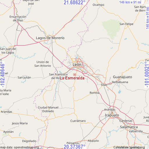
La Esmeralda GPS coordinates[2]
21° 1' 53.004" North, 101° 42' 11.988" West
| Map corner | latitude | longitude |
|---|---|---|
| Upper-left | 21.68622°, | -102.40646° |
| Center: | 21.03139°, | -101.70333° |
| Lower-right: | 20.37367°, | -101.00021° |
| Map W x H: | 145.9×145.9 km | = 90.7×90.7mi |
| max Lat: | 32.7° ⇑23.1% North |
| La Esmeralda: | 21.03139° |
| min Lat: | ⇓76.9% South 14.53588° |
| min Long | La Esmeralda | max Long |
| -117.105° | -101.70333° | -86.73105° |
| W 21%⇐ | ⇒79% E |
Elevation
Elevation of La Esmeralda is 1780 m = 5840 ft, and this is 526.3 m = 1727 ft above average elevation for this country.
| Max E: |
3497 m = 11473 ft | 36.9% |
| La Esmeralda | 1780 m 5840 ft | |
| Avg. | 1253.7 m = 4113 ft | |
Min E: |
-1 m = -3 ft | 63.1% |
See also: Mexico elevation on elevation.city.
Geographical zone
La Esmeralda is located in North Torrid zone (between Equator and Tropic of Cancer). Distance of this Northern Tropic circle is 267.4 km =166.2 mi to North.| Distance of | km | miles | from La Esmeralda |
|---|---|---|---|
| North Pole | 7668.6 | 4765 | to North |
| Arctic Circle | 5062.7 | 3145.8 | to North |
| Tropic Cancer | 267.4 | 166.2 | to North |
| Equator | 2338.5 | 1453.1 | to South |


Nearby cities:
15 places around La Esmeralda: (largest is in red/bold)
• Colonia Latinoamericana
0.3 km =0.2 mi,  244°
244°
• El CERESO
1.8 km =1.1 mi,  124°
124°
• El Puente
0.8 km =0.5 mi,  289°
289°
• El Ramillete
6.7 km =4.2 mi,  278°
278°
• Los Arcos
2.5 km =1.6 mi,  37°
37°
• Los Ramírez
6.3 km =3.9 mi,  102°
102°
• Malagana (San Antonio del Monte)
5.5 km =3.4 mi, 288°
• Plan de Ayala
4.9 km =3 mi,  337°
337°
• Rústico San Pedro
0.3 km =0.2 mi,  312°
312°
• San Antonio de los Tepetates
3.2 km =2 mi,  62°
62°
• San Cristóbal
6 km =3.7 mi,  176°
176°
• San Isidro de las Colonias
2 km =1.2 mi, 285°
• San José de Durán (Los Troncoso)
4.6 km =2.9 mi, 40°
• San Pedro del Monte (La Huizachera)
1.2 km =0.7 mi,  269°
269°
• Santa Ana
4.2 km =2.6 mi, 42°
Sources, notices
• [Note1] Compared only with cities in Mexico existing in our database
• [Src1] Map data: © OpenStreetMap contributors (CC-BY-SA)
• [Src2] Other city data from geonames.org with taken over terms of usage.
• [Src3] Geographical zone / Annual Mean Temperature by Robert A. Rohde @ Wikipedia
