Los Ramírez geodata
Los Ramírez (Guanajuato) is a populated place; located in Mexico in America/Mexico_City (GMT-6) time zone. With population of 2,473 people, there are 3578 cities with bigger population in this country. Compared to other cities in Mexico, 76.7% of cities are located further ↓South; 78.6% of cities are located further →East and 63.6% of cities have lower elevation than Los Ramírez. Note1


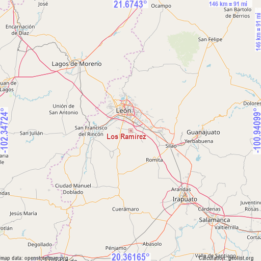
Los Ramírez GPS coordinates[2]
21° 1' 9.912" North, 101° 38' 38.796" West
| Map corner | latitude | longitude |
|---|---|---|
| Upper-left | 21.6743°, | -102.34724° |
| Center: | 21.01942°, | -101.64411° |
| Lower-right: | 20.36165°, | -100.94099° |
| Map W x H: | 146×146 km | = 90.7×90.7mi |
| max Lat: | 32.7° ⇑23.3% North |
| Los Ramírez: | 21.01942° |
| min Lat: | ⇓76.7% South 14.53588° |
| min Long | Los Ramírez | max Long |
| -117.105° | -101.64411° | -86.73105° |
| W 21.4%⇐ | ⇒78.6% E |
Elevation
Elevation of Los Ramírez is 1792 m = 5879 ft, and this is 538.3 m = 1766 ft above average elevation for this country.
| Max E: |
3497 m = 11473 ft | 36.4% |
| Los Ramírez | 1792 m 5879 ft | |
| Avg. | 1253.7 m = 4113 ft | |
Min E: |
-1 m = -3 ft | 63.6% |
See also: Mexico elevation on elevation.city.
Geographical zone
Los Ramírez is located in North Torrid zone (between Equator and Tropic of Cancer). Distance of this Northern Tropic circle is 268.8 km =167 mi to North.| Distance of | km | miles | from Los Ramírez |
|---|---|---|---|
| North Pole | 7669.9 | 4765.9 | to North |
| Arctic Circle | 5064 | 3146.6 | to North |
| Tropic Cancer | 268.8 | 167 | to North |
| Equator | 2337.1 | 1452.2 | to South |


Nearby cities:
15 places around Los Ramírez: (largest is in red/bold)
• Capellanía de Loera
5.1 km =3.2 mi,  70°
70°
• Colonia Latinoamericana
6.5 km =4 mi,  280°
280°
• El CERESO
4.7 km =2.9 mi,  273°
273°
• El Resplandor
4.5 km =2.8 mi,  115°
115°
• La Esmeralda
6.3 km =3.9 mi, 282°
• Los Arcos
5.7 km =3.5 mi,  305°
305°
• Noria de Septién (San José de San Juan)
4.8 km =3 mi,  2°
2°
• Nueva Colonia San Carlos
6.2 km =3.9 mi,  58°
58°
• Rancho Nuevo de la Luz
6.3 km =3.9 mi,  181°
181°
• Rústico San Pedro
6.6 km =4.1 mi, 283°
• San Antonio de los Tepetates
4.4 km =2.7 mi, 310°
• San Francisco de Durán
3 km =1.9 mi, 122°
• San José de Durán (Los Troncoso)
5.8 km =3.6 mi,  327°
327°
• San Juan de Abajo
4.2 km =2.6 mi,  12°
12°
• Santa Ana
5.5 km =3.4 mi,  323°
323°
Sources, notices
• [Note1] Compared only with cities in Mexico existing in our database
• [Src1] Map data: © OpenStreetMap contributors (CC-BY-SA)
• [Src2] Other city data from geonames.org with taken over terms of usage.
• [Src3] Geographical zone / Annual Mean Temperature by Robert A. Rohde @ Wikipedia
