El Tamarindo geodata
El Tamarindo (Veracruz) is a populated place; located in Mexico in America/Mexico_City (GMT-6) time zone. With population of 616 people, there are 13995 cities with bigger population in this country. Compared to other cities in Mexico, 68.6% of cities are located further ↑North; 78% of cities are located further ←West and 70.4% of cities have higher elevation than El Tamarindo. Note1


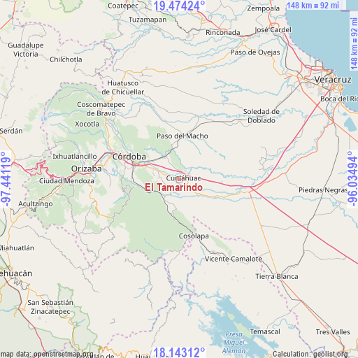
El Tamarindo GPS coordinates[2]
18° 48' 36" North, 96° 44' 17.016" West
| Map corner | latitude | longitude |
|---|---|---|
| Upper-left | 19.47424°, | -97.44119° |
| Center: | 18.81°, | -96.73806° |
| Lower-right: | 18.14312°, | -96.03494° |
| Map W x H: | 148×148 km | = 92×92mi |
| max Lat: | 32.7° ⇑68.6% North |
| El Tamarindo: | 18.81° |
| min Lat: | ⇓31.4% South 14.53588° |
| min Long | El Tamarindo | max Long |
| -117.105° | -96.73806° | -86.73105° |
| W 78%⇐ | ⇒22% E |
Elevation
Elevation of El Tamarindo is 400 m = 1312 ft, and this is 853.7 m = 2801 ft below average elevation for this country.
| Max E: |
3497 m = 11473 ft | 70.4% |
| Avg. | 1253.7 m = 4113 ft | |
| El Tamarindo | 400 m = 1312 ft | |
Min E: |
-1 m = -3 ft | 29.6% |
See also: Mexico elevation on elevation.city.
Geographical zone
El Tamarindo is located in North Torrid zone (between Equator and Tropic of Cancer). Distance of this Northern Tropic circle is 514.4 km =319.6 mi to North.| Distance of | km | miles | from El Tamarindo |
|---|---|---|---|
| North Pole | 7915.6 | 4918.5 | to North |
| Arctic Circle | 5309.7 | 3299.3 | to North |
| Tropic Cancer | 514.4 | 319.6 | to North |
| Equator | 2091.5 | 1299.6 | to South |


Nearby cities:
15 places around El Tamarindo: (largest is in red/bold)
• Adolfo López Mateos (San José de Enmedio)
5.6 km =3.5 mi,  271°
271°
• Arroyo Azul
5.8 km =3.6 mi,  75°
75°
• Corral de Piedra
5.6 km =3.5 mi,  333°
333°
• Cuitláhuac
1.7 km =1.1 mi,  73°
73°
• División del Norte (Santa Rosa)
2.5 km =1.6 mi,  25°
25°
• El Maguey
2.6 km =1.6 mi,  8°
8°
• General Alatriste (San Joaquín)
6.7 km =4.2 mi,  299°
299°
• Los Mangos
2.8 km =1.7 mi,  289°
289°
• Mata Naranjo
4.5 km =2.8 mi,  144°
144°
• Palmillas
3.6 km =2.2 mi,  279°
279°
• San Francisco (Mata Clara)
1 km =0.6 mi, 300°
• San Francisco de las Mesillas
4.6 km =2.9 mi, 298°
• San José de Abajo
5.6 km =3.5 mi,  227°
227°
• Toluquilla Buena Vista
7.1 km =4.4 mi,  184°
184°
• Yanga
6.8 km =4.2 mi, 291°
Sources, notices
• [Note1] Compared only with cities in Mexico existing in our database
• [Src1] Map data: © OpenStreetMap contributors (CC-BY-SA)
• [Src2] Other city data from geonames.org with taken over terms of usage.
• [Src3] Geographical zone / Annual Mean Temperature by Robert A. Rohde @ Wikipedia
