El Maguey geodata
El Maguey (Veracruz) is a populated place; located in Mexico in America/Mexico_City (GMT-6) time zone. With population of 1,413 people, there are 6121 cities with bigger population in this country. Compared to other cities in Mexico, 68.2% of cities are located further ↑North; 78% of cities are located further ←West and 70.5% of cities have higher elevation than El Maguey. Note1


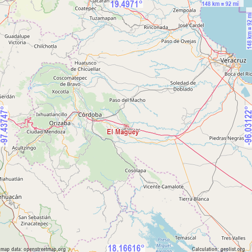
El Maguey GPS coordinates[2]
18° 49' 58.62" North, 96° 44' 3.624" West
| Map corner | latitude | longitude |
|---|---|---|
| Upper-left | 19.4971°, | -97.43747° |
| Center: | 18.83295°, | -96.73434° |
| Lower-right: | 18.16616°, | -96.03122° |
| Map W x H: | 148×148 km | = 92×92mi |
| max Lat: | 32.7° ⇑68.2% North |
| El Maguey: | 18.83295° |
| min Lat: | ⇓31.8% South 14.53588° |
| min Long | El Maguey | max Long |
| -117.105° | -96.73434° | -86.73105° |
| W 78%⇐ | ⇒22% E |
Elevation
Elevation of El Maguey is 395 m = 1296 ft, and this is 858.7 m = 2817 ft below average elevation for this country.
| Max E: |
3497 m = 11473 ft | 70.5% |
| Avg. | 1253.7 m = 4113 ft | |
| El Maguey | 395 m = 1296 ft | |
Min E: |
-1 m = -3 ft | 29.5% |
See also: Mexico elevation on elevation.city.
Geographical zone
El Maguey is located in North Torrid zone (between Equator and Tropic of Cancer). Distance of this Northern Tropic circle is 511.9 km =318.1 mi to North.| Distance of | km | miles | from El Maguey |
|---|---|---|---|
| North Pole | 7913 | 4916.9 | to North |
| Arctic Circle | 5307.1 | 3297.7 | to North |
| Tropic Cancer | 511.9 | 318.1 | to North |
| Equator | 2094 | 1301.2 | to South |


Nearby cities:
15 places around El Maguey: (largest is in red/bold)
• Adolfo López Mateos (San José de Enmedio)
6.5 km =4 mi,  248°
248°
• Arroyo Azul
5.4 km =3.4 mi,  101°
101°
• Corral de Piedra
3.8 km =2.4 mi,  310°
310°
• Cuitláhuac
2.4 km =1.5 mi,  149°
149°
• División del Norte (Santa Rosa)
0.7 km =0.4 mi,  111°
111°
• El Tamarindo
2.6 km =1.6 mi,  188°
188°
• General Alatriste (San Joaquín)
6.3 km =3.9 mi,  277°
277°
• General Francisco Paz (El Poblado)
7.6 km =4.7 mi, 278°
• Los Mangos
3.4 km =2.1 mi,  241°
241°
• Mata Naranjo
6.6 km =4.1 mi,  160°
160°
• Palmillas
4.4 km =2.7 mi, 243°
• Paso Mulato
6.3 km =3.9 mi,  42°
42°
• San Francisco (Mata Clara)
2.4 km =1.5 mi,  211°
211°
• San Francisco de las Mesillas
4.4 km =2.7 mi,  265°
265°
• Yanga
6.7 km =4.2 mi, 269°
Sources, notices
• [Note1] Compared only with cities in Mexico existing in our database
• [Src1] Map data: © OpenStreetMap contributors (CC-BY-SA)
• [Src2] Other city data from geonames.org with taken over terms of usage.
• [Src3] Geographical zone / Annual Mean Temperature by Robert A. Rohde @ Wikipedia
