La Aurora geodata
La Aurora (Chiapas) is a populated place; located in Mexico in America/Mexico_City (GMT-6) time zone. With population of 609 people, there are 14153 cities with bigger population in this country. Compared to other cities in Mexico, 84.2% of cities are located further ↑North; 95.5% of cities are located further ←West and 72.5% of cities have higher elevation than La Aurora. Note1


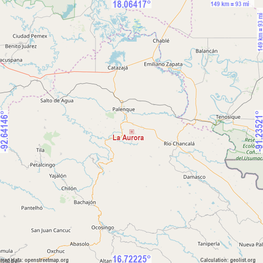
La Aurora GPS coordinates[2]
17° 23' 39.984" North, 91° 56' 17.988" West
| Map corner | latitude | longitude |
|---|---|---|
| Upper-left | 18.06417°, | -92.64146° |
| Center: | 17.39444°, | -91.93833° |
| Lower-right: | 16.72225°, | -91.23521° |
| Map W x H: | 149.2×149.2 km | = 92.7×92.7mi |
| max Lat: | 32.7° ⇑84.2% North |
| La Aurora: | 17.39444° |
| min Lat: | ⇓15.8% South 14.53588° |
| min Long | La Aurora | max Long |
| -117.105° | -91.93833° | -86.73105° |
| W 95.5%⇐ | ⇒4.5% E |
Elevation
Elevation of La Aurora is 312 m = 1024 ft, and this is 941.7 m = 3090 ft below average elevation for this country.
| Max E: |
3497 m = 11473 ft | 72.5% |
| Avg. | 1253.7 m = 4113 ft | |
| La Aurora | 312 m = 1024 ft | |
Min E: |
-1 m = -3 ft | 27.5% |
See also: Mexico elevation on elevation.city.
Geographical zone
La Aurora is located in North Torrid zone (between Equator and Tropic of Cancer). Distance of this Northern Tropic circle is 671.8 km =417.4 mi to North.| Distance of | km | miles | from La Aurora |
|---|---|---|---|
| North Pole | 8073 | 5016.3 | to North |
| Arctic Circle | 5467.1 | 3397.1 | to North |
| Tropic Cancer | 671.8 | 417.4 | to North |
| Equator | 1934.1 | 1201.8 | to South |


Nearby cities:
15 places around La Aurora: (largest is in red/bold)
• Adolfo Ruiz Cortínes
4.8 km =3 mi,  259°
259°
• Arimatea
8.8 km =5.5 mi,  131°
131°
• Babilonia
11.1 km =6.9 mi,  329°
329°
• Belisario Domínguez
5 km =3.1 mi,  285°
285°
• Doctor Samuel León Brindis
4.6 km =2.9 mi,  8°
8°
• Estrella de Belén
2.3 km =1.4 mi,  249°
249°
• Francisco I. Madero
12.6 km =7.8 mi, 255°
• Ignacio Zaragoza
10.1 km =6.3 mi,  280°
280°
• Jerusalén
13.3 km =8.3 mi, 257°
• Nazareth
2.7 km =1.7 mi,  204°
204°
• Nueva Galilea
12.5 km =7.8 mi, 133°
• Nuevo Sonora
6.3 km =3.9 mi,  60°
60°
• Profresor Roberto Barrios
7.7 km =4.8 mi,  170°
170°
• Puyipa
5.3 km =3.3 mi,  180°
180°
• San Miguel
8.1 km =5 mi,  244°
244°
Sources, notices
• [Note1] Compared only with cities in Mexico existing in our database
• [Src1] Map data: © OpenStreetMap contributors (CC-BY-SA)
• [Src2] Other city data from geonames.org with taken over terms of usage.
• [Src3] Geographical zone / Annual Mean Temperature by Robert A. Rohde @ Wikipedia
