Nueva Galilea geodata
Nueva Galilea (Chiapas) is a populated place; located in Mexico in America/Mexico_City (GMT-6) time zone. With population of 843 people, there are 10377 cities with bigger population in this country. Compared to other cities in Mexico, 85.1% of cities are located further ↑North; 95.7% of cities are located further ←West and 73.2% of cities have higher elevation than Nueva Galilea. Note1


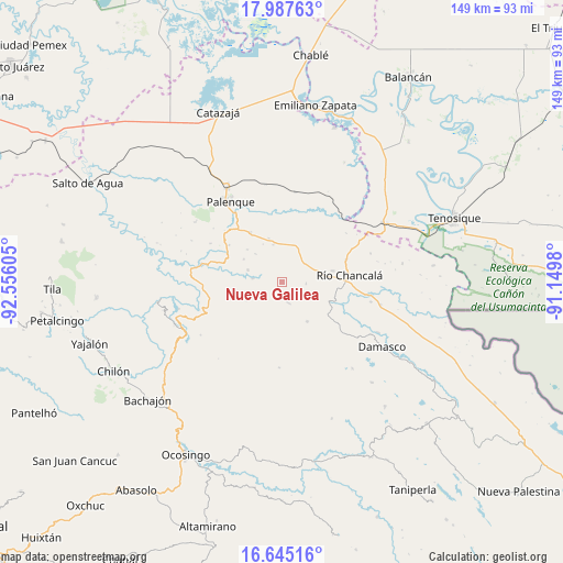
Nueva Galilea GPS coordinates[2]
17° 19' 3.432" North, 91° 51' 10.512" West
| Map corner | latitude | longitude |
|---|---|---|
| Upper-left | 17.98763°, | -92.55605° |
| Center: | 17.31762°, | -91.85292° |
| Lower-right: | 16.64516°, | -91.1498° |
| Map W x H: | 149.3×149.3 km | = 92.8×92.8mi |
| max Lat: | 32.7° ⇑85.1% North |
| Nueva Galilea: | 17.31762° |
| min Lat: | ⇓14.9% South 14.53588° |
| min Long | Nueva Galilea | max Long |
| -117.105° | -91.85292° | -86.73105° |
| W 95.7%⇐ | ⇒4.3% E |
Elevation
Elevation of Nueva Galilea is 280 m = 919 ft, and this is 973.7 m = 3195 ft below average elevation for this country.
| Max E: |
3497 m = 11473 ft | 73.2% |
| Avg. | 1253.7 m = 4113 ft | |
| Nueva Galilea | 280 m = 919 ft | |
Min E: |
-1 m = -3 ft | 26.8% |
See also: Mexico elevation on elevation.city.
Geographical zone
Nueva Galilea is located in North Torrid zone (between Equator and Tropic of Cancer). Distance of this Northern Tropic circle is 680.4 km =422.8 mi to North.| Distance of | km | miles | from Nueva Galilea |
|---|---|---|---|
| North Pole | 8081.5 | 5021.6 | to North |
| Arctic Circle | 5475.6 | 3402.4 | to North |
| Tropic Cancer | 680.4 | 422.8 | to North |
| Equator | 1925.5 | 1196.4 | to South |


Nearby cities:
15 places around Nueva Galilea: (largest is in red/bold)
• Agua Blanca Serranía
5.8 km =3.6 mi,  161°
161°
• Arimatea
3.6 km =2.2 mi,  316°
316°
• El Progreso
4.4 km =2.7 mi,  203°
203°
• Estrella de Belén
13.6 km =8.5 mi,  304°
304°
• Hermenegildo Galeana
6.5 km =4 mi,  93°
93°
• La Aurora
12.5 km =7.8 mi,  313°
313°
• La Cascada
7.9 km =4.9 mi,  41°
41°
• Nazareth
11.8 km =7.3 mi, 300°
• Nuevo San Joaquín
11 km =6.8 mi,  113°
113°
• Nuevo Sonora
12.2 km =7.6 mi,  342°
342°
• Profresor Roberto Barrios
7.9 km =4.9 mi,  276°
276°
• Puyipa
9.7 km =6 mi,  289°
289°
• Río Jordán
11.6 km =7.2 mi,  226°
226°
• San Jerónimo Tulijá
12.4 km =7.7 mi,  147°
147°
• San Juan Chancalaíto
13.7 km =8.5 mi,  78°
78°
Sources, notices
• [Note1] Compared only with cities in Mexico existing in our database
• [Src1] Map data: © OpenStreetMap contributors (CC-BY-SA)
• [Src2] Other city data from geonames.org with taken over terms of usage.
• [Src3] Geographical zone / Annual Mean Temperature by Robert A. Rohde @ Wikipedia
